Geographical analysis
Department of Geography & GIS
Department of Geography & GIS
Geographical analysis
Year: 2020, Volume: 9, Issue: 1, Pages: 52-58
Original Article
Holly Dehingia1, P Surendra2
1M.Sc. Student, Department of Geography, Bangalore University, Bengaluru, Karnataka, India
2Assistant Professor, Department of Geography, Bangalore University, Bengaluru, Karnataka,
India
Received Date:11 March 2020, Accepted Date:24 May 2020
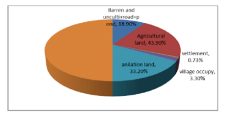
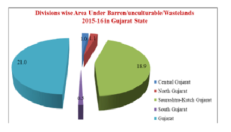
Land use and land cover transformation have turned out to be a dynamic factor in recent strategies for dealing with natural resources and monitoring environmental changes. The research aimed to assessment of Land use and Land cover pattern of Gujarat State. The study area was classified and mapped into four broad land cover classes i.e., agriculture, fallow, barren/unculturable/wastelands, built-up, forest, wet lands and water bodies. The land use and land cover data were collected from NRSC of the year 2015-16. The state has been categorized into four divisions i.e., Central Gujarat, north Gujarat, Saurashtra-Kutch & south Gujarat. The Land use and land cover of Gujarat state to the geographical area of the state has 52.1% of its area under agriculture, 6.3% of fallow land, 21.0% of Barren/Unculturable/wastelands, 2.7% of Builtup, 11.1% of forest, 3.4% of wetlands and 3.4% of water bodies.
Keywords: Land Use; Land Cover
© 2020 Dehingia & Surendra. This is an open-access article distributed under the terms of the Creative Commons Attribution License, which permits unrestricted use, distribution, and reproduction in any medium, provided the original author and source are credited.
Published By Bangalore University, Bengaluru, Karnataka
Subscribe now for latest articles and news.