Geographical analysis
Department of Geography & GIS
Department of Geography & GIS
Geographical analysis
DOI: 10.53989/bu.ga.v12i1.23.3_hegde
Year: 2023, Volume: 12, Issue: 1, Pages: 34-38
Original Article
Rajendra Hegde1, M B Mahendra Kumar2*, K V Seema2, K V Niranjana3, B A Dhanorkar3
1Principal Scientist & Head, ICAR-National Bureau of Soil Survey and Land Use Planning, Hebbal Regional Centre, Bangalore, Karnataka, 560024, India
2Senior Research Fellow, ICAR-National Bureau of Soil Survey and Land Use Planning, Hebbal Regional Centre, Bangalore, Karnataka, 560024, India
3Chief Technical Officer, ICAR-National Bureau of Soil Survey and Land Use Planning, Hebbal Regional Centre, Bangalore, 560024, Karnataka, India
*Corresponding Author
Email: [email protected]
Received Date:07 February 2022, Accepted Date:22 December 2022
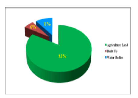
The study was undertaken with the use of remote sensing and GIS for delineating and planning. For land use/land cover (LULC) mapping, the standard procedure has been used and finally with the help of geospatial technology (ArcGIS10.2.2 software version) the mapping was done. The study area was classified into three land cover classes i.e., agriculture, built-up and water bodies. The majority of the area in the microwatershed was covered by agricultural land (83%) followed by water body (11%) and built up (6%) land. This classification and the land use map will be beneficial to the policy makers, farmers, NGO’s and field agricultural officers for planning and development of this watershed. Also rainwater harvesting structures can be provided after estimating the runoff potential and accordingly rainwater conservation structures can be planned for sustainable LULC management.
Keywords: Remote Sensing, GIS, LULC, Geospatial, Agricultural, Water Body, Built Up
© 2023 Hegde et al. This is an open-access article distributed under the terms of the Creative Commons Attribution License, which permits unrestricted use, distribution, and reproduction in any medium, provided the original author and source are credited.
Published By Bangalore University, Bengaluru, Karnataka
Subscribe now for latest articles and news.