Geographical analysis
Department of Geography & GIS
Department of Geography & GIS
Geographical analysis
DOI: 10.53989/bu.ga.v11i2.22.3
Year: 2022, Volume: 11, Issue: 2, Pages: 30-38
Original Article
N Chendrayudu1*
1HOD, Dept. of Geography, Sri Venkateswara University, 517502, Tirupati
*Corresponding Author
Email: [email protected]
Received Date:18 March 2022, Accepted Date:20 May 2022
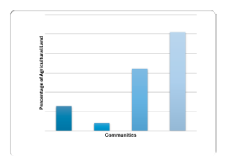
In drought prone Rayalaseema region agriculture is the principal occupation of the people and is influencing the land use pattern. The study of Farmer’s perception on land use and its planning has a considerable importance. To find out the farmers perception on the agricultural land use pattern in Chittoor district of Rayalaseema region, farmer's opinion on land use pattern and its related aspects have been collected. For this, a field survey was conducted through questionnaire with different parameters like total agriculture land, land under different crops, total cultivated area, area under food crops, area under commercial crops, land under fruit gardens, land under fallow land. etc. For this 6 mandals have been selected for sample field survey. The sample mandals are selected on the basis of factors like mandals which are located in drought prone area, located in high rain fall receiving area. located in irrigation source area, located in fruit growing dominance and areas with high intensity of commercial cropping pattern. Apart from these factors, distribution of mandals based on nature of topography like plain, valley and plateau land forms were also taken in to account. To know the farmers perception on cropping pattern. 6 mandals have been selected for sample field survey. The study has indicated agricultural land use, cropped area, crops cultivated, shifting from traditional cropping system to commercial and cash crops in different farming communities.
Keywords: Perception, Holdings Commercial Cropping, Mechanization, Drought Prone Area
Ali Mohannad, (1978): Studies in Agricultural geography. Rajesh publications, New Delhi, pp352
Chandrayudu. N. and Ramanaiah, Y.V.. (1994): Typification of Agriculture and Typological regions: A case study of Chittoor district. A.P. National geographer, vol. XXIX. No.2. PP.99-106.
Chendrayudu. N. (1993) Typification of agriculture at micro regional seale. A case study of Chittoor district, Andhra Pradesh..
Deshpande, C.D. (1959), Pompore: A Reconnaissance study in Land use in the Kashmir valley, Bombay6 Geographical Magazine, Vol, VI-Vii, No.1, and PP.3-4
Ganguli, B.N. (1964) Land use and agricultural Planning, Geographical Review of India, Vol. 26. PP-53-72
Gupta J. P (2007) land use planning in India.
Kostrowicki, J. (1960) Land Utilization Survey as a Basis for tieographical Typology of Agriculture. Przeqlad Geograficzny 32. Pp. 169-183.
© 2022 Chendrayudu. This is an open-access article distributed under the terms of the Creative Commons Attribution License, which permits unrestricted use, distribution, and reproduction in any medium, provided the original author and source are credited.
Published By Bangalore University, Bengaluru, Karnataka
Subscribe now for latest articles and news.