Geographical analysis
Department of Geography & GIS

Department of Geography & GIS

Geographical analysis
Year: 2024, Volume: 13, Issue: 2, Pages: 34-44
Original Article
S Sushmitha1∗, B Chandrashekara2
1Research Scholar, DoS in Geography, University of Mysuru, Manasagangothri Campus, Mysuru, Karnataka, India
2Professor, DoS in Geography, University of Mysuru, Manasagangothri Campus, Mysuru, Karnataka, India
*Corresponding Author
Email: [email protected]
Received Date:05 December 2024, Accepted Date:25 December 2024
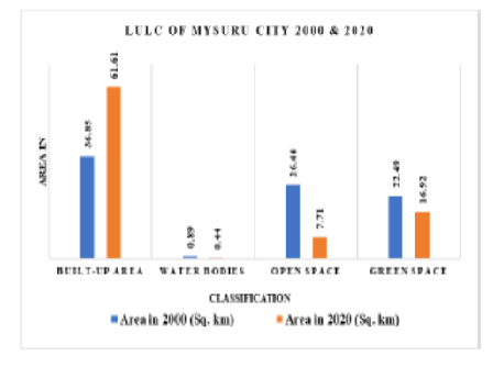
With an emphasis on the loss of urban green spaces as a result of urban growth, this study examines the Land Use and Land Cover (LULC) dynamics in Mysuru City, India, over a 20-year period between 2000 and 2020. Four main LULC classes—Built-up Area, Water Bodies, Open Space, and Green Space—were examined using remote sensing and GIS techniques to evaluate the temporal and spatial variations in land cover. The objective of the study is to understand the level of greenery in urban environment of Mysuru city as Mysuru is currently subjected to increased population and unbridled urbanization. The findings raise questions about ecological health and sustainable urban development since they show a notable increase in built-up areas at the expense of green and open Spaces.
Keywords: Urban Green Space, Land Use Land Cover, Remote Sensing, GIS, Mysuru City
© 2024 Sushmitha & Chandrashekara. This is an open-access article distributed under the terms of the Creative Commons Attribution License, which permits unrestricted use, distribution, and reproduction in any medium, provided the original author and source are credited.
Published By Bangalore University, Bengaluru, Karnataka
Subscribe now for latest articles and news.