Geographical analysis

Department of Geography & GIS

Article

Geographical analysis

Year: 2022, Volume: 11, Issue: 2, Pages: 16-29

Original Article

Hydrological Inferences from Watershed Analysis for Sustainable Water Management Using Geoinformatics Approach

Received Date:02 April 2022, Accepted Date:22 December 2022

Abstract

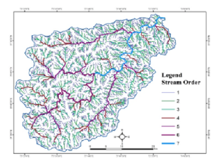
The rapid growth of urbanization, industrialization, an exponential increase in population and change of climate along with uneven distribution of rainfall make proper water management and planning of storage is very challenging. Satellite-based geoinformatics technology has supported to be an efficient tool in the analysis of drainage networks, surface morphological features, and interrelation with groundwater management at the watershed level. Geoinformatics approach such as remote sensing and Geographic information system has used for extraction of watershed analysis using Cartosat Digital Elevation Model (DEM) satellite images for assessment of drainage and extraction of their relative parameters For the Darna watershed in Nashik district, Maharashtra. In the study Hydrological parameters drainage analysis, topographical parameters, and land-use patterns has evaluated and interpreted for sustainable watershed management. The results reveals that Cartosat Data Dem based hydrological evaluation of watershed-scale is applied and accurate compared to available various technique.

Keywords: CARTOSAT-DEM, Geoinformatics, LISS­IV, Darna Basin, Watershed

References

  1. Thakur JK, Thakur RK, Ramanathan AL, Kumar M, Singh SK. Arsenic Contamination of Groundwater in Nepal—An Overview. Water. 2011;3(1):1–20. Available from: https://doi.org/10.3390/w3010001
  2. Singh P, Gupta A, Singh M. Hydrological inferences from watershed analysis for water resource management using remote sensing and GIS techniques. The Egyptian Journal of Remote Sensing and Space Science. 2014;17(2):111–121. Available from: https://doi.org/10.1016/j.ejrs.2014.09.003
  3. Jha MK, Chowdhury A, Chowdary VM, Peiffer S. Groundwater management and development by integrated remote sensing and geographic information systems: prospects and constraints. Water Resources Management. 2007;21(2):427–467. Available from: https://doi.org/10.1007/s11269-006-9024-4
  4. Panhalkar SS, Mali SP, Pawar CT. Morphometric analysis and watershed development prioritization of Hiranyakeshi Basin in Maharashtra. International Journal of Environmental Science. 2012;3(1):525–534. Available from: https://vidyaprabodhinicollege.edu.in/wp-content/uploads/2022/08/2.EIJES31052.pdf
  5. Malik A, Kumar A, Kandpal H. Morphometric analysis and prioritization of sub-watersheds in a hilly watershed using weighted sum approach. Arabian Journal of Geosciences. 2019;12(4):118. Available from: https://doi.org/10.1007/s12517-019-4310-7
  6. Strahler AN. Quantitative geomorphology of drainage basins and channel networks. (pp. 4-11) New York. McGraw Hill Book Company. 1964.
  7. Sreedevi PD, Sreekanth PD, Khan HH, Ahmed S. Drainage morphometry and its influence on hydrology in an semi arid region: using SRTM data and GIS. Environmental Earth Sciences. 2013;70(2):839–848. Available from: https://doi.org/10.1007/s12665-012-2172-3
  8. Bobba AG, Bukata RP, Jerome JH. Digitally processed satellite data as a tool in detecting potential groundwater flow systems. Journal of Hydrology. 1992;131(1-4):25–62. Available from: https://doi.org/10.1016/0022-1694(92)90212-E
  9. Meijerink A. Groundwater. In: SG, EE., eds. Remote Sensing in Hydrology and Water Management. (pp. 305-325) Springer Berlin Heidelberg. 2000.
  10. Magesh NS, Jitheshlal KV, Chandrasekar N, Jini KV. Geographical information system-based morphometric analysis of Bharathapuzha river basin, Kerala, India. Applied Water Science. 2013;3(2):467–477. Available from: https://doi.org/10.1007/s13201-013-0095-0
  11. Grohmann CH, Riccomini C, Alves FM. SRTM-based morphotectonic analysis of the Poços de Caldas Alkaline Massif, southeastern Brazil. Comput Geosci. 2007;33:10–19. Available from: https://doi.org/10.1016/j.cageo.2006.05.002
  12. Murthy, Yvn S, Rao S, Rao P, Jayaraman DS, V. The International Archives of the photogrammetry, remote sensing and spatial information sciences. (Vol. 37, pp. 1343-1348) Beijing. 2008.
  13. Dabrowski R, Fedorowicz-Jackowski W, Kedzierski M, Walczykowski P, Zych J. The international archives of the photogrammetry, remote sensing and spatial information sciences. 2008;37:1309–1313.
  14. Srivastava PK, Srinivasan TP, Gupta A, Singh S, Nain JS, Amitabh, et al. Recent Advances In Cartosat-1 data processing, proceedings of ISPRS international symposium ''high-resolution earth imaging for geospatial information. Hannover, Germany. 2007.
  15. Muralikrishnan S, Pillai A, Narender B, Reddy S, Venkataraman VR, Dadhwal VK. Validation of Indian National DEM from Cartosat-1 Data. Journal of the Indian Society of Remote Sensing. 2013;41(1):1–13. Available from: https://doi.org/10.1007/s12524-012-0212-9
  16. Reddy GPO, Maji AK, Gajbhiye KS. Drainage morphometry and its influence on landform characteristics in a basaltic terrain, Central India – a remote sensing and GIS approach. International Journal of Applied Earth Observation and Geoinformation. 2004;6(1):1–16.
  17. Valeriano MM, Kuplich TM, Storino M, Amaral BD, Mendes JN, Lima DJ. Modeling small watersheds in Brazilian Amazonia with shuttle radar topographic mission-90m data. Computers & Geosciences. 2006;32(8):1169–1181. Available from: https://doi.org/10.1016/j.cageo.2005.10.019
  18. Nag SK, Lahiri A. Morphometric analysis of Dwarakeswar watershed, Bankura district, West Bengal, India, using spatial information technology. International Journal of Water Resources and Environmental Engineering. 2011;3(10):212–219. Available from: https://academicjournals.org/journal/IJWREE/article-full-text-pdf/64FC87E54617.pdf
  19. Nag SK. Morphometric analysis using remote sensing techniques in the chaka sub-basin, purulia district, West Bengal. Journal of the Indian Society of Remote Sensing. 1998;26(1-2):69–76. Available from: https://doi.org/10.1007/BF03007341
  20. Lindsay JB, Creed IF, Beall FD. Drainage basin morphometrics for depressional landscapes. Water Resources Research. 2004;40(9):9307. Available from: https://doi.org/10.1029/2004WR003322
  21. Mesa LM. Morphometric analysis of a subtropical Andean basin (Tucumán, Argentina) Environmental Geology. 2006;50(8):1235–1242. Available from: https://doi.org/10.1007/s00254-006-0297-y
  22. Deng Y. New trends in digital terrain analysis: landform definition, representation, and classification. Progress in Physical Geography: Earth and Environment. 2007;31(4):405–419. Available from: https://doi.org/10.1177/030913330708129
  23. Wilson JP, Aggett G, Yongxin D, Lam CS. Water in the Landscape: A Review of Contemporary Flow Routing Algorithms. In: ZQ, LB, TG., eds. Lecture Notes in Geoinformation and Cartography. (Vol. 3, pp. 213-236) Springer Berlin Heidelberg. 2008.
  24. Wang D, Laffan SW, Liu Y, Wu L. Morphometric characterisation of landform from DEMs. International Journal of Geographical Information Science. 2010;24(2):305–326. Available from: https://doi.org/10.1080/13658810802467969
  25. Jacques PD, Salvador ED, Machado R, Grohmann CH, Nummer AR. Application of morphometry in neotectonic studies at the eastern edge of the Paraná Basin, Santa Catarina State, Brazil. Geomorphology. 2014;213:13–23. Available from: https://doi.org/10.1016/j.geomorph.2013.12.037
  26. Chopra R, Dhiman RD, Sharma PK. Morphometric analysis of sub-watersheds in Gurdaspur district, Punjab using remote sensing and GIS techniques. Journal of the Indian Society of Remote Sensing. 2005;33(4):531–539. Available from: https://doi.org/10.1007/BF02990738
  27. Dar RA, Chandra R, Romshoo SA. Morphotectonic and lithostratigraphic analysis of intermontane Karewa Basin of Kashmir Himalayas, India. Journal of Mountain Science. 2013;10(1):1–15. Available from: https://doi.org/10.1007/s11629-013-2494-y
  28. Prabu P, Baskaran R. Drainage morphometry of upper Vaigai river sub-basin, Western Ghats, South India using remote sensing and GIS. Journal of the Geological Society of India. 2013;82(5):519–528. Available from: https://doi.org/10.1007/s12594-013-0183-7
  29. Suwandana E, Kawamura K, Sakuno Y, Kustiyanto E, Raharjo B. Evaluation of ASTER GDEM2 in Comparison with GDEM1, SRTM DEM and Topographic-Map-Derived DEM Using Inundation Area Analysis and RTK-dGPS Data. Remote Sensing. 2012;4(8):2419–2431. Available from: https://doi.org/10.3390/rs4082419
  30. Elabanavi S, Lamani S. Hypsometric Analysis of the Malaprabha Sub Basin of Krishna River, Karnataka, India. International Journal for Research in Applied Science and Engineering Technology. 7(7):846–850. Available from: https://doi.org/10.22214/ijraset.2019.7136
  31. Bhatt S, Ahmed SA. Morphometric analysis to determine floods in the Upper Krishna basin using Cartosat DEM. Geocarto International. 2014;29(8):878–894. Available from: https://doi.org/10.1080/10106049.2013.868042
  32. Strahler AN. Hypsometric (area-altitude) analysis of erosional topography. Geological Society of America Bulletin. 1952;63(11):1117.
  33. Zomlot Z, Verbeiren B, Huysmans M, Batelaan O. Spatial distribution of groundwater recharge and base flow: Assessment of controlling factors. Journal of Hydrology: Regional Studies. 2015;4:349–368. Available from: https://doi.org/10.1016/j.ejrh.2015.07.005
  34. Schumm SA. The evolution of drainage systems and slopes in badlands at Perth Amboy, New Jersey. Geological Society of America Bulletin. 1956;67(5):597.
  35. Wentworth CK. A simplified method of determining the average slope of land surfaces. American Journal of Science. 1930;s5-20(117):184–194. Available from: http://ui.adsabs.harvard.edu/abs/1930AmJS...20..184W/abstract
  36. Chorley RJ, Malm DEG, Pogorzelski HA. A new standard for estimating drainage basin shape. American Journal of Science. 1957;255(2):138–141. Available from: https://doi.org/10.2475/ajs.255.2.138
  37. Horton RE. Drainage-basin characteristics. Trans Am Geophys Union. 1932;13:350–361.
  38. Smart JS, Surkan AJ. The relation between mainstream length and area in drainage basins. Water Resources Research. 1967;3(4):963–974. Available from: https://doi.org/10.1029/WR003i004p00963
  39. Faniran A. The index of drainage intensity-a provisional new drainage factor. Aust J Sci. 1968;31:328–330.
  40. Singh S, Dubey A. Geoenvironmental planning of watershed in India. (pp. 28-69) Allahabad. Chugh Publications. 1994.
  41. Hack J. Studies of longitudinal stream profiles in Virginia and Maryland. (pp. 294) US Geological Survey. 1957.
  42. Strahler AN. Quantitative geomorphology of drainage basins and channel networks. In: VTC., ed. Handbook of Applied Hydrology. McGraw Hill Book Company. 1964.
  43. Strahler AN. Quantitative analysis of watershed geomorphology. Trans Am Geophys Union. 1957;38:913–920.
  44. Strahler AN. DIMENSIONAL ANALYSIS APPLIED TO FLUVIALLY ERODED LANDFORMS. Geological Society of America Bulletin. 1958;69(3):279.

Copyright

© 2022 Gadakh & Jaybhaye. This is an open-access article distributed under the terms of the Creative Commons Attribution License, which permits unrestricted use, distribution, and reproduction in any medium, provided the original author and source are credited.

Published By Bangalore University, Bengaluru, Karnataka

DON'T MISS OUT!

Subscribe now for latest articles and news.