Geographical analysis
Department of Geography & GIS
Department of Geography & GIS
Geographical analysis
Year: 2021, Volume: 10, Issue: 1, Pages: 1-7
Original Article
Shahnin Irfan ✉ 1 , Ashok D Hanjagi 2
Received Date:02 January 2021, Accepted Date:12 March 2021
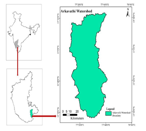
According to FAO, World’s 33% of land has been degraded and continue to degrade even in the future. At the same time, world’s population has crossed 8 billion putting more stress on land resources. Rapid urbanization, industrialization, infrastructure development has led to shrink earths land resources. There is huge challenge how the existing land has been used in logistic way. Bangalore which is one of the fastest rising metropolitan hubs in the world is facing major crisis regarding land use. The Arkavathy river that flows through Bangalore Metropolitan is also facing the difficulties in scientific use of land. The watershed lies in the western part of Bangalore Metropolitan Region in Karnataka. Land-Use change has a noteworthy influence on watershed developments such as hydrology, soil loss, carbon confiscation, etc. Hence, the study emphases on the Land use of Arkavathy watershed of Karnataka, India. This study tries to attempt and highlight the change in Land use of the watershed in last three decades. The drastic change in the watershed in last few many years has wider ramification on the environment on regional scale. Multispectral satellite data obtained from Landsat 4 for 2001, IRS P6 LISS IV for and Sentinel-2 for 2018 to classify the watershed. The watershed has been classified into six major classes viz. Agricultural Land, Forest or vegetation cover, Built-up, Wastelands, grazingland and waterbodies. The overall, set-up presented by the study discloses that the land use change is quite visible throughout the study area.
Keywords: Land use, watershed, Change, development
© 2021 Irfan & Hanjagi. This is an open-access article distributed under the terms of the Creative Commons Attribution License, which permits unrestricted use, distribution, and reproduction in any medium, provided the original author and source are credited.
Published By Bangalore University, Bengaluru, Karnataka
Subscribe now for latest articles and news.