Geographical analysis

Department of Geography & GIS

Article

Geographical analysis

Year: 2024, Volume: 13, Issue: 2, Pages: 20-26

Original Article

Spatial Patterns and Multiple Linear Regression Model for Forest Settlement and Vegetation using Remote Sensing and Geospatial Techniques. A Case Study in Sirumalai Hill

Received Date:24 July 2024, Accepted Date:12 September 2024

Abstract

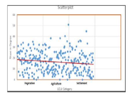
Accessing localized information in densely forested areas poses significant challenges. This study utilizes Sentinel-2 imagery with 10m NDVI data to derive a detailed vegetation map, complemented by high-resolution Google Earth feature identification for cross-verification. The primary aim is to map the forest landscape comprehensively and analyze the spatial patterns of settlements and forest-agriculture interactions within the forest, using publicly available data sources. The study specifically examines areas with slopes exceeding 23.8 degrees, which are unsuitable for settlements due to the heightened risk of landslides. By correlating NDVI data with slope calculations through a multiple linear regression model, the study identifies significant statistical relationships, with an R² value of 0.2 and a P-value of 0.006. Results indicate that the forest's spatial structure supports two distinct settlement patterns: linear settlements on slopes ranging from 0 to 8.6 degrees and scattered settlements on slopes between 16.22 and 23.79 degrees. These findings highlight the critical influence of slope on settlement distribution. This research provides valuable insights into the living environments of forest residents and underscores the importance of sustainable forest ecosystem management.

Keywords: Remote Sensing, Recoding, Unsupervised classification, NDVI, LCLU, DEM, Sirumalai, Settlement pattern 2

References

  1. Yansui L. Family Models used in optimal allocation of regional land use. Progress in Geography. 1999;18(1):26–31. Available from: https://doi.org/10.11820/dlkxjz.1999.01.004
  2. Wu M, Yang C, Song X, Hoffmann WC, Huang W, Niu Z, et al. Monitoring cotton root rot by synthetic Sentinel-2 NDVI time series using improved spatial and temporal data fusion. Scientific Reports. 2018;8(1):1–12. Available from: https://doi.org/10.1038/s41598-018-20156-z
  3. Lange M, Dechant B, Rebmann C, Vohland M, Cuntz M, Doktor D. Validating MODIS and Sentinel-2 NDVI Products at a Temperate Deciduous Forest Site Using Two Independent Ground-Based Sensors. Sensors. 2017;17(8):1–18. Available from: https://doi.org/10.3390/s17081855
  4. Potapov P, Yaroshenko A, Turubanova S, Dubinin M, Laestadius L, Thies C, et al. Mapping the World's Intact Forest Landscapes by Remote Sensing. Ecology and Society. 2008;13(2):1–16. Available from: https://dx.doi.org/10.5751/es-02670-130251
  5. Singh P, Gupta A, Singh M. Hydrological inferences from watershed analysis for water resource management using remote sensing and GIS techniques. The Egyptian Journal of Remote Sensing and Space Science. 2014;17(2):111–121. Available from: https://doi.org/10.1016/j.ejrs.2014.09.003
  6. Prodanovic D, Stanić M, Milivojević V, Simić Z, Arsic M. DEM-based GIS algorithms for automatic creation of hydrological models data. Journal of the Serbian Society for Computational Mechanics. 2009;3(1):64–85. Available from: https://core.ac.uk/download/pdf/219108983.pdf
  7. Mondal A, Khare D, Kundu S, Mondal S, Mukherjee S, Mukhopadhyay A. Spatial soil organic carbon (SOC) prediction by regression kriging using remote sensing data. The Egyptian Journal of Remote Sensing and Space Science. 2017;20(1):61–70. Available from: https://doi.org/10.1016/j.ejrs.2016.06.004
  8. Baskent EZ, Jordan GA, . Designing forest management to control spatial structure of landscapes. Landscape and Urban Planning. 1996;34(1):55–74. Available from: https://doi.org/10.1016/0169-2046(95)00200-6
  9. Baskent EZ, Jordan GA. Characterizing spatial structure of forest landscapes. Canadian Journal of Forest Research. 1995;25(11):1830 –1849. Available from: https://doi.org/10.1139/x95-198
  10. JS, Bartrand T, Ravenscroft J, Molina M, Whelan G, Schoen M, et al. Estimated human health risks from recreational exposures to stormwater runoff containing animal faecal material. Environmental Modelling & Software. 2015;72:21–32. Available from: https://doi.org/10.1016/j.envsoft.2015.05.018
  11. Sankar RV, Kottaimuthu R, Ravikumar K. Additions to the flora of Sirumalai hills, Eastern Ghats, India. Journal of Threatened Taxa. 2009;1(7):379–381. Available from: https://dx.doi.org/10.11609/jott.o2069.379-81
  12. Jensen JR. Introductory digital image processing: A remote sensing perspective. (pp. 1-623) Pearson Education, Incorporated. 2016.
  13. Navalgund RR, Jayaraman V, Kumar ASK, et al. Remote Sensing Data Acquisition, Platforms, and Sensor Requirements. Journal of the Indian Society of Remote Sensing. 1996;24:207–237. Available from: https://doi.org/10.1007/BF03026230
  14. Depicker A, Jacobs L, Mboga N, Smets B, Rompaey AV, Lennert M, et al. Landslide risk trends in the Kivu Rift and the impact of environmental and societal dynamics. EGU General Assembly. 2021;p. 19–30. Available from: https://doi.org/10.5194/egusphere-egu21-8927, 2021
  15. Lehmann P, Ruette JV, Or D. Deforestation effects on rainfall-induced shallow landslides: remote sensing and physically-based modelling. Water Resources Research. 2019;55(11):9962–9976. Available from: https://doi.org/10.1029/2019WR025233
  16. Dhakal AS, Sidle RC. Long-term modeling of landslides for different forest management practices. Earth Surface Processes and Landforms. 2003;28(8):853–868. Available from: https://doi.org/10.1002/esp.499
  17. Li X, Yeh AGO, Wang S, Liu X, Liu K, Qian J, et al. Regression and analytical models for estimating mangrove wetland biomass in South China using Radarsat images. International Journal of Remote Sensing. 2007;28(24):5567–5582. Available from: https://doi.org/10.1080/01431160701227638

Copyright

© 2024 Chandramohan et al. This is an open-access article distributed under the terms of the Creative Commons Attribution License, which permits unrestricted use, distribution, and reproduction in any medium, provided the original author and source are credited.

Published By Bangalore University, Bengaluru, Karnataka

DON'T MISS OUT!

Subscribe now for latest articles and news.