Geographical analysis
Department of Geography & GIS
Department of Geography & GIS

Geographical analysis
Year: 2015, Volume: 4, Issue: 1, Pages: 26-32
Original Article
Patil N.P.,* Kadale A.S.** MhetreG.S.***
*Ph.D. Research Scholar, Dr. Babasaheb Ambedkar Marathwada University,
Aurangabad
**Co-ordinator, All India Co-ordinated Research Project on Water Management, VNMKV, Parbhani.
***RS & GIS Associate, Divisional Joint Director of Agriculture, Latur
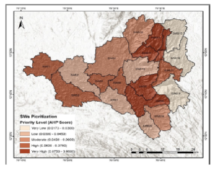
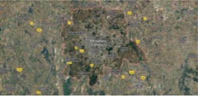
Abstract The study area is Karwadi-Nandapur watershed is a micro watershed which falls in the Kayadhu river watershed in Marathwada region of Maharashtra.Using the remotely sensed images of the Indian Remote Sensing Satellite P6 (IRS P6), Linear Imaging Self Scanner III(LISS III) images captured in October 2010 and November 2011 having resolution of 23.5m X 23.5m and images from Google Earth Pro of study area were used and cartosat satellites. Map of India with scale 1:15,00,000 and soil maps of India were used for the experimental study. The thematic maps like drainage map, land use and land cover map, soil maps and contour map were prepared adopting the PCI Geomatica10.0 software. The geographical information systems (GIS) analysis was made for the said themes using the Arc GIS – ArcMap10.0. The Karwadi- Nandapur watershed was found to be the third order basin. The present study aims to assess the morphometric characteristics of the watershed basin and it has been assessed by applying GIS techniques. Strahler’s method has been employed to assess the fluvial characteristics of the study watershed. Each morphometric characteristic is considered as a single parameter and knowledge based weight age has been assigned by considering its role in soil erosion. The morphometric properties determined for this watershed as a whole and for each watershed will be useful for the efficient planning of water harvesting and groundwater projects on watershed basis.
Key words: Morphometric, Remote sensing.
Subscribe now for latest articles and news.