Geographical analysis
Department of Geography & GIS
Department of Geography & GIS
Geographical analysis
Year: 2024, Volume: 13, Issue: 2, Pages: 1-9
Original Article
Pankaj Kumar1, B C Vishwanath2∗, Ashok D Hanjagi3, B Mahalingam2, Mehtab Singh Rathore4
1Department of Geography & Geoinformatics, Bangalore University, Jnanabharathi Campus, Bengaluru, 560056, Karnataka
2Assistant Professor, Department of Geography, Central University of Karnataka, Kalaburagi, 585367, Karnataka
3Professor & HOD, Department of Geography & Geoinformatics, Bangalore University, Jnanabharathi Campus, Bengaluru, 560056, Karnataka
4Assistant Professor, Department of Geography, Shri Govind Guru Government College, Banswara, Rajasthan
*Corresponding Author
Email: [email protected]
[email protected]
Received Date:28 October 2024, Accepted Date:01 December 2024
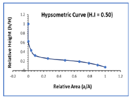
The Barakar River Basin, originating near Padma in Hazaribagh, Jharkhand, is a key tributary of the Damodar River. Covering an area of about 7077 sq km with a perimeter of 686.38 km, this basin plays a critical role in the hydrology of the region, influencing water availability, sediment transport, and flood dynamics. This study focuses on a detailed geomorphological evaluation, utilizing high-resolution DEM data (12.5 m) from ALOS PALSAR, to assess the erosional processes and landscape development of the basin. A series of hypsometric and morphometric analyses were conducted to derive critical parameters such as slope, relief, drainage density, and stream order. The elevation of the basin was categorized into 10 distinct classes, ranging from 36.1 meters to 1319 meters, allowing for a comprehensive assessment of its relief structure. A hillshade map was also generated to visualize terrain and slope more effectively. Stream ordering, based on Strahler's method, revealed a maximum stream order of 5, signifying a well-established drainage network crucial for sediment transport and flow regulation. Using ArcGIS Pro 3.0.1, additional morphometric indices such as the basin shape, elongation ratio, and bifurcation ratio were calculated, offering valuable insights into the basin's susceptibility to erosion and flooding. The hypsometric integral (HI) of 0.50 for the Barakar River Basin indicates a mature stage of geomorphic development, where erosion and upliftment are balanced. Around half of the basin's original landscape has been eroded, with substantial areas leveled but retaining some relief. This reflects significant erosional shaping over time, with further flattening expected as the basin continues evolving towards a more stable topography. This mature stage of development calls for careful basin management to mitigate erosion, control sediment load, and preserve water resources. This study provides critical insights into the geomorphological evolution of the Barakar Basin, offering practical implications for flood control and sediment management in the broader Damodar River system.
Keywords: Hypsometric curve, Morphometric Analysis, Barakar Basin, Stream Order
© 2024 Kumar et al. This is an open-access article distributed under the terms of the Creative Commons Attribution License, which permits unrestricted use, distribution, and reproduction in any medium, provided the original author and source are credited.
Published By Bangalore University, Bengaluru, Karnataka
Subscribe now for latest articles and news.