Geographical analysis
Department of Geography & GIS
Department of Geography & GIS
Geographical analysis
Year: 2024, Volume: 13, Issue: 2, Pages: 27-33
Original Article
Viranch N Dave1∗, Mudit D Mankad2, Kamlesh Sharma3
1PhD Candidate, Department of Geography, The Maharaja Sayajirao University of Baroda, Vadodara, 390005, Gujarat, India
2Assistant Professor (Level 11- Senior Scale), Department of Geography, The Maharaja Sayajirao University of Baroda, Vadodara, 390005, Gujarat, India
3Additional Director, Public Relations, Government of Rajasthan, Jaipur, 302005, Rajasthan, India
*Corresponding Author
Email: [email protected]
Received Date:06 August 2024, Accepted Date:28 December 2024
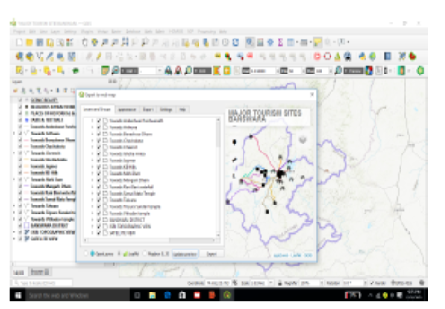
Information regarding tourist sites plays a vital role in attracting tourism. Tourists derive information regarding the site from traditional pamphlets circulated by travel agencies and tourism departments. But as the digital paperless economy is way ahead, Webmaps can help local and foreign tourists get information regarding tourist sites on their gadgets. WebGIS integrates spatial and non-spatial data, helping to overcome the limitations of several websites that give only factual information on tourist sites. Information regarding tourist sites in the Banswara district of Rajasthan State (India) is not properly available. This study used QGIS to create a webmap showing important tourist sites in Banswara district. Field visits were carried out to collect the latitude and longitude of sites. These locations were exported as points, and attribute data was attached in QGIS. The final output is derived using the qgis2web plugin. Plugins like HCMGIS and ORS were used to add base layers and find the shortest routes. The webmap is published using the WordPress system as a webpage to provide site-specific information to tourists, like its location, importance, and description. A usability examination showed the webmap's strengths and weaknesses. Users found the content to be precise and the overall design to be creative and interactive. With recommendations to add real-time information, there is possibility to make the webmap better in the future.
Keywords: Webmap, Tourism, Open source, Google Earth, KML
© 2024 Dave et al. This is an open-access article distributed under the terms of the Creative Commons Attribution License, which permits unrestricted use, distribution, and reproduction in any medium, provided the original author and source are credited.
Published By Bangalore University, Bengaluru, Karnataka
Subscribe now for latest articles and news.