Geographical analysis
Department of Geography & GIS

Department of Geography & GIS

Geographical analysis
Year: 2018, Volume: 7, Issue: 1, Pages: 1-3
Original Article
H A Muniraja 1
1 Research Scholar, Department of Geography, Bangalore University, Janana Bharati Campus, Bangalore
Received Date:12 January 2018, Accepted Date:24 April 2018
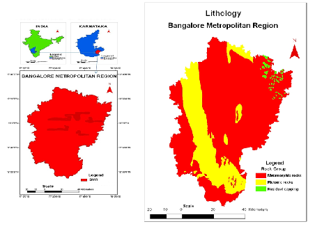
Bangalore was built by Magadi Kempegowda at 1537. Bangalore ruled by various kingdom in 1758- Hyder Ali, in 1799- British overthrew Tippu sultan, in 1881- Mysore wodeyar, After the independence, Bangalore was designed as the capital of Mysore state in 1956, Bangalore Metropolitan Region comprises Bangalore urban district, Bangalore rural district & Ramanagara district. The Bangalore Metropolitan Region lies towards the south-east in the south Indian state of Karnataka. The Bangalore Metropolitan Region situated between 12◦ 14’ 16” to 13◦ 30’ 26” north latitude & 77◦ 2’ 51” to 77◦ 57’ 45” east longitude. The total geographical area of Bangalore Metropolitan Region is 8005 sq. Km. The main aim of the paper are To Know Topography of Bangalore Metropolitan Region. To Mapping Topography of Bangalore Metropolitan Region. To reach set goals first literature collected from various works and to prepare maps for topography of Bangalore metropolitan region remote sensing data and GIS techniques are used. Bangalore is fast growing metropolitan city hence to know and mapping of the topography is required.
Keywords: Topography; Lithology; soil; remote sensing
© 2018 Muniraja. This is an open-access article distributed under the terms of the Creative Commons Attribution License, which permits unrestricted use, distribution, and reproduction in any medium provided the original author and source are credited.
Published By Bangalore University, Bengaluru, Karnataka
Subscribe now for latest articles and news.