Geographical analysis
Department of Geography & GIS
Department of Geography & GIS
Geographical analysis
Year: 2021, Volume: 10, Issue: 1, Pages: 45-51
Original Article
P Surendra1∗, A H Saurabh2
1 Assistant Professor Department of Geography, Bangalore University, Bengaluru, Karnataka, India
2 Student, Bangalore University, Bengaluru, Karnataka, India
*Corresponding author email: [email protected]
Received Date:11 February 2021, Accepted Date:25 May 2021
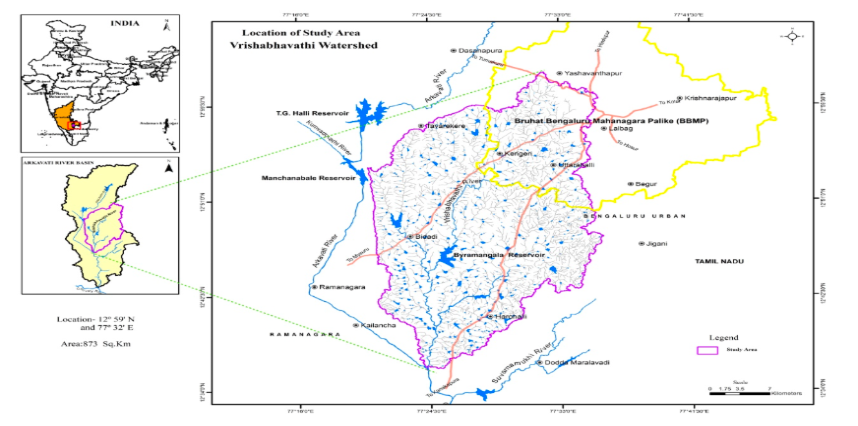
The Arkavathi watershed, Bangalore Urban, and Ramanagara are all parts of the Vrishabhavathi River district. This River, a tributary of the River Arkavathi, which enters the River Cauvery, serves as the primary supply of surface water. It drains a major parts of Bangalore metropolis and is an outlet for domestic and industrial effluent of that area. It is an outlet for the domestic and industrial wastewater of the Bangalore metropolis and drains a sizable portion of the city. Previously, drinking and agriculture were the principal uses for this surface water. Because of the location of this watershed in both urban and rural Bangalore, this water is now solely used for unsafe agricultural purposes. The current study has been conducted to map the geographical variability of the surface water quality in the watershed in order to assess the surface water quality. The results and analysis showed that most sampling sites’ water quality is not suitable for drinking water purposes. It is also limited to the usage of other activities because of the degradation of water quality. The Nitrate content is high in a few of the groundwater samples collected. The bicarbonate content is more in all the samples. The study, therefore, emphasized the need for periodic monitoring of water levels, the management of industrial effluents before discharge into the river, and the introduction of appropriate mitigation strategies to resolve problems and deterioration to facilitate the safe state of the river. Only 40 percent of the industries have got the facility to treat wastewater. They have installed Effluent Treatment Plant (ETP).
Keywords: Industrial effluent, Wastewater, Water quality, Contamination
© 2021 Surendra & Saurabh. This is an open-access article distributed under the terms of the Creative Commons Attribution License, which permits unrestricted use, distribution, and reproduction in any medium, provided the original author and source are credited.
Published By Bangalore University, Bengaluru, Karnataka
Subscribe now for latest articles and news.