Geographical analysis
Department of Geography & GIS
Department of Geography & GIS

Geographical analysis
Year: 2014, Volume: 3, Issue: 2, Pages: 18-25
Original Article
Charutha Reghunathan *, Anilkumar R.**
*Research scholar, Department of Geography, University College, Thiruvananthapuram|
** KSTSTE Emeritus Scientist
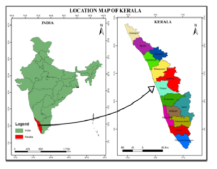
Land being the most important natural resource on earth and the basis for all development, human beings alter it in a way useful for them. In an era of uncontrollable population growth, it is impossible to keep land free from human interventions. The study was done in Thiruvananthapuram district, the capital of Kerala state. The district is the seat of administrative and commercial functions and also an upcoming IT centre. With the increasing population and high population density, it can be opined that population is the major cause of land use change in the district. The study made use of Survey of India Topographic sheets and satellite imageries for extracting land use data. Demographic details were taken from various census publications. Spatial interpolation and buffer analysis was done using Arc GIS 9.3 software. The analysis revealed that population increase has an active role in the changing land use of the district. Intensity of population increase as well as land use change shows a decreasing trend with the increasing distance from the city corporation area which is the focal point of growth in the district.
Key words: Land use change, demographic change, interpolation, buffer analysis
© 2014 This is an open-access article distributed under the terms of the Creative Commons Attribution License, which permits unrestricted use, distribution, and reproduction in any medium, provided the original author and source are credited.
Published By Bangalore University, Bengaluru, Karnataka
Subscribe now for latest articles and news.