Geographical analysis

Department of Geography & GIS

Article

Geographical analysis

Year: 2025, Volume: 14, Issue: 1, Pages: 30-41

Original Article

Application of Geographic Information System (GIS) in Analyzing the Spatial Distribution of Socio-economic Amenities in Pulwama District, UT of Jammu and Kashmir

Received Date:31 October 2024, Accepted Date:08 June 2025

Abstract

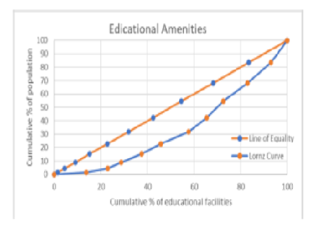
Physical access to basic services and facilities inspires the quality of life and living environ of the community, as they are essential to interpret the standard of living individuals enjoy in a peculiar location. This study intends to investigate the spatial disparity and concentration of basic amenities in the Pulwama district of Jammu and Kashmir using GIS. Inequality in the study region is demonstrated in the form of uneven provision of social and economic amenities. Three basic facilities consisting of educational facilities, health care institutions (social amenities) and financial institutions (economic amenities) were analyzed and visualized, using Geographic information system (GIS) Technology. The study mainly relied on secondary sources of data. Two techniques namely the Z-score variate and Location Quotient have been employed to investigate the level of spatial clustering pattern in allocating selected amenities. However, the GINI coefficient along with the Lorenz curve technique has been utilized for accessing and computing the spatial disparity among the selected amenities. The results convey that imbalances exist in the provision of availability of selected amenities among different blocks in the district, as certain blocks are more advanced in terms of the accessibility of particular facilities while others fall well short of the average degree of development.

Keywords: Geographic Information System (GIS), Socio-economic amenities, Z-score variate, Location Quotient, GINI coefficient, Jammu and Kashmir

References

  1. Aderamo AJ, Aina OA. Spatial Inequalities in Accessibility to Social Amenities in Developing Countries: A Case from Nigeria. Australian Journal of Basic and Applied Sciences. 2011;5(6):316–322. Available from: https://www.ajbasweb.com/old/ajbas/2011/june-2011/316-322.pdf
  2. Kundu A, Bagchi S, Kundu D. Regional Distribution of Infrastructure and Basic Amenities in Urban India: Issues concerning Empowerment of Local Bodies. Economic and Political Weekly. 1999;34(28):1893–1906. Available from: http://www.jstor.org/stable/4408183
  3. Borana SL, Yadav SK. Spatial Inequalities in Accessibility of Public Amenities in Jodhpur City. International Journal of Advanced Research in Computer and Communication Engineering. 2017;6(10):225–230. Available from: http://dx.doi.org/10.17148/IJARCCE.2017.61040
  4. Bhat MS. Urban System in Himalayas: A Study of Srinagar City-Region. Dilpreet Publications. 2008.
  5. Mulligan GF, Carruthers JI. Amenities, Quality of Life, and Regional Development, Social Indicators Research Series. (Vol. 45, pp. 107-133) Springer. 2011.
  6. Obu JI, Obienusi EA, Ozoemene ML, Iwu EO. Spatial Inequality in Development: A Case Study of Anambra State, Nigeria. International Journal of Physical and Human Geography. 2015;3(4):1–26. Available from: https://www.eajournals.org/wp-content/uploads/Spatial-Inequality-In-Development-A-Case-Study-Of-Anambah-State-Nigeria.pdf
  7. Parry JA, Ganaie SA, Nengroo ZA, Bhat MS. Spatial Analysis on the provision of Urban Amenities and their Deficiencies - A Case Study of Srinagar City, Jammu and Kashmir, India. Research on Humanities and Social Sciences. 2012;2(6):192–219. Available from: https://www.iiste.org/Journals/index.php/RHSS/article/view/2393
  8. Bhagat RB, Hassan MI. Urbanisation and Access to Basic Amenities, Exploring Urban Change in South Asia. (pp. 123-141) Springer Nature Singapore. 2025.
  9. Kalam APJA. Ignited Minds: Unleashing the Power Within India. New Delhi, India. Penguin Books. 2003.
  10. Akanbi A, Kumar S, Fidelis U. Application of Remote Sensing, GIS and GPS for efficient Urban Management Plan, A case study of part of Hyderabad city. Novus International Journal of Engineering & Technology. 2013;2(4):1–14. Available from: https://arxiv.org/pdf/1312.4932
  11. Chen S, Zeng S, Xie C. Remote Sensing and GIs for Urban Growth Analysis in China . Photogrammetric Engineering & Remote Sensing . 2000;66(5):593–598. Available from: https://www.asprs.org/wp-content/uploads/pers/2000journal/may/2000_may_593-598.pdf
  12. Black M, Ebener S, Hamrick PN, Vidaurre M, EZ, Morjani ZEAEE. Using GIS to measure physical accessibility to health care. World Health Organization. 2004;p. 1–22. Available from: https://proceedings.esri.com/library/userconf/health04/papers/pap3023.pdf
  13. Kibon UA, Ahmed M. Distribution of Primary Health Care Facilities in Kano Metropolis Using GIS (Geographic Information System) Research Journal of Environmental and Earth Sciences. 2013;5(4):167–176. Available from: https://dx.doi.org/10.19026/rjees.5.5710
  14. Lone SA, Ali S, Singh H. Spatial analysis on the provisions of educational amenities in North Kashmir [J&K]-India. Sustainability, Agri, Food and Environmental Research. 2023;12(2):1–9. Available from: https://dx.doi.org/10.7770/safer-v13n1-art556
  15. Perks C, Toole MJ, Phouthonsy K. District health programmes and health-sector reform: case study in the Lao People's Democratic Republic. Bulletin of the World Health Organization. 2006;84(2):132–138. Available from: https://doi.org/10.2471/blt.05.025403
  16. Jamtsho S, Corner RJ. Evaluation of spatial accessibility to primary healthcare using GIS. ISPRS Annals of the Photogrammetry, Remote Sensing and Spatial Information Sciences. 2014;II-2:79–86. Available from: https://dx.doi.org/10.5194/isprsannals-ii-2-79-2014
  17. Oliver A, Mossialos E. Equity of access to health care: outlining the foundations for action. Journal of Epidemiology & Community Health. 2004;58(8):655–658. Available from: https://doi.org/10.1136/jech.2003.017731
  18. Arora RU, Anand PB. Regional financial disparity in India: can it be measured? Journal of Institutional Economics. 2021;17(5):836–860. Available from: https://dx.doi.org/10.1017/s1744137421000291
  19. Gadhe UN. Urbanization: a case study of Raigad district, Maharashtra. Scholarly Research Journal for Interdisciplinary Studies. 2017;4(29):4853–4859. Available from: https://www.srjis.com/downloadPdf/157389645561.%20Uttam%20N.%20Gadhe%201.pdf/4561/72
  20. Lorenz MO. Methods of Measuring the Concentration of Wealth. Publications of the American Statistical Association. 1905;9(70):209–219. Available from: https://doi.org/10.2307/2276207
  21. Parry JA, Kuchay NA, Ganaie SA, Bhat MS. Spatial analysis of urban amenities in Srinager city Jammu and Kashmir. Global Journal of Arts Humanities and Social Sciences. 2013;1(1):20–31. Available from: https://www.researchgate.net/publication/352764675_SPATIAL_ANALYSIS_OF_URBAN_AMENITIES_IN_SRINAGER_CITY_JAMMU_AND_KASHMIR

Copyright

© 2025 Nazir & Gadhe. This is an open-access article distributed under the terms of the Creative Commons Attribution License, which permits unrestricted use, distribution, and reproduction in any medium, provided the original author and source are credited.

Published By Bangalore University, Bengaluru, Karnataka

DON'T MISS OUT!

Subscribe now for latest articles and news.