Geographical analysis
Department of Geography & GIS
Department of Geography & GIS
Geographical analysis
Year: 2024, Volume: 13, Issue: 1, Pages: 25-29
Original Article
K Shrikrishna1, Sawant Sushant Anil2∗, Shivanand Chinnappanavar3, R Soundarya1
1Student, School of Life Sciences, JSS Academy of Higher Education and Research, Mysuru, Karnataka, India
2Assistant Professor/Course Coordinator, School of Life Sciences, , JSS Academy of Higher Education and Research, Mysuru, Karnataka
3Associate Professor, Department of Geography, Regional Institute of Education, Mysuru, Karnataka, India
*Corresponding Author
Email: [email protected]
Received Date:29 February 2024, Accepted Date:04 March 2024
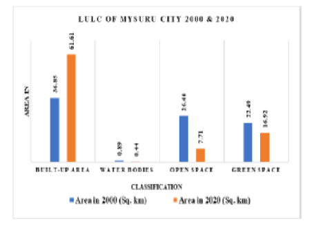
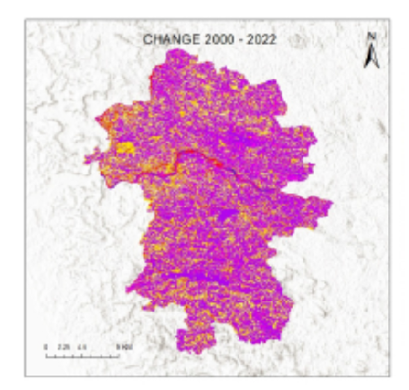
For various decision support systems, the detection of land use and land cover (LULC) change based on remote sensing data is a crucial source of information. Land conservation, sustainable development, and the management of water resources all benefit from the information gathered through the detection of changes in land use and land cover. Therefore, determining the change in land use and land cover over Bantwala is the aim of this study. For images from Landsat 7 (MSS, TM) and Landsat 8 (OLI, TIRS) taken in 2000 and 2022, obtained from the USGS earth explorer website, supervised land use & land cover classification has been done. For the accuracy of the classification, user's and producer's accuracy are calculated, and it found that the accuracy of users and producers is well accepted, and the overall accuracy calculated was 87% and 88%, respectively. A massive change from forest cover to built-up (68.45 sq. Km) and agriculture (68.26 sq. Km) is seen. These changes are seen in the study region due to population growth and the need to practice agriculture.
Keywords: Land use and land cover, Change Detection, Accuracy
© 2024 Shrikrishna et al. This is an open-access article distributed under the terms of the Creative Commons Attribution License, which permits unrestricted use, distribution, and reproduction in any medium, provided the original author and source are credited.
Published By Bangalore University, Bengaluru, Karnataka
Subscribe now for latest articles and news.