Geographical analysis

Department of Geography & GIS

Article

Geographical analysis

Year: 2023, Volume: 12, Issue: 1, Pages: 1-12

Original Article

Tracing and Analysis of Urban Footprint and its Future Implications in an Emerging Metropolis of Mysuru, India, Using Geoinformatics Techniques

Received Date:12 February 2023, Accepted Date:15 May 2023

Abstract

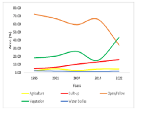
Rapid urbanization is a global phenomenon that is exerting a substantial influence on the land use and land cover. In India, urbanization is occurring at an unparalleled rate, with the urban population expected to double by 2050. Small and mid-sized cities in the developing world are witnessing a substantial increase in urban expansion, indicating a significant upward trend. This rapid growth presents numerous challenges and opportunities, putting a strain on natural resources and leading to environmental degradation. Regrettably, small and mid-sized cities like Mysuru have been overlooked and excluded from policy negotiations in India, despite presenting a crucial opportunity for targeted action and intervention. In the current study, the dynamics of urban expansion in the mid-sized city of Mysuru, located in southern India. The research utilizes earth observation and geoinformatics techniques to assess land use and land cover changes in the rapidly urbanizing areas surrounding Mysuru for the years 1995, 2001, 2007, 2014, and 2022. The study area has witnessed dynamic changes in land use and land cover triggered by rapid urban growth accounting for 235 per cent during the last 27 years. The open/fallow and vegetation land was converted to meet the growing demand for built-up areas in Mysuru, challenging sustainable development. The study's findings offer valuable perspectives on the scope and characteristics of urbanization, along with the related alterations in land use and land cover, within Mysuru and its environs. The findings can inform decision-making processes for urban planning, resource management, and environmental conservation. The study contributes to filling the gap in research on emergent small and mid-sized cities, particularly in southern part of India, and emphasizes the importance of sustainable planning for the future development of these cities.

Keywords: LULC, Urban Growth, Mid­Sized City, Remote Sensing, GIS

References

  1. Uma SM, Shankar B, Rego J. An Overview of Agriculture in Mysore District: Proposal of an Agriculture Hub in Mysore City. International Journal of Recent Technology and Engineering. 2021;10(4). Available from: https://www.ijrte.org/wp-content/uploads/papers/v10i4/C64810910321.pdf
  2. Singh B, Venkatramanan V, Deshmukh B. Monitoring of land use land cover dynamics and prediction of urban growth using Land Change Modeler in Delhi and its environs, India. Environmental Science and Pollution Research. 2022;29(47):71534–71554. Available from: https://doi.org/10.1007/s11356-022-20900-z
  3. Bhatta B, Saraswati S, Bandyopadhyay D. Quantifying the degree-of-freedom, degree-of-sprawl, and degree-of-goodness of urban growth from remote sensing data. Applied Geography. 2010;30(1):96–111. Available from: https://doi.org/10.1016/j.apgeog.2009.08.001
  4. Pradhan, Charan K. Unacknowledged Urbanisation: The New Census Towns in India. Exploring Urban Change in South Asia. 2017;48:39–66. Available from: https://mpra.ub.uni-muenchen.de/41035/2/Unacknowledged_Urbanisation.pdf
  5. Laidley T. The Problem of Urban Sprawl. Contexts. 2016;15(3):74–77.
  6. Freeman L. The Effects of Sprawl on Neighborhood Social Ties:<i>An Explanatory Analysis</i>. Journal of the American Planning Association. 2001;67(1):69–77. Available from: https://doi.org/10.1080/01944360108976356
  7. Han L, Zhou W, Li W, Li L. Impact of urbanization level on urban air quality: A case of fine particles (PM 2.5 ) in Chinese cities. Environmental Pollution. 2014;194:163–170.
  8. Mundoli S, Manjunath B, Nagendra H. Effects of urbanisation on the use of lakes as commons in the peri-urban interface of Bengaluru, India. International Journal of Urban Sustainable Development. 2015;7(1):89–108. Available from: https://doi.org/10.1080/19463138.2014.982124
  9. Garouani AE, Mulla DJ, Garouani SE, Knight J. Analysis of urban growth and sprawl from remote sensing data: Case of Fez, Morocco. International Journal of Sustainable Built Environment. 2017;6(1):160–169. Available from: https://doi.org/10.1016/j.ijsbe.2017.02.003
  10. Fertner C, Jørgensen G, Nielsen TAS, Nilsson KSB. Urban sprawl and growth management – drivers, impacts and responses in selected European and US cities. Future Cities and Environment. 2016;2(0):9. Available from: https://doi.org/10.1186/s40984-016-0022-2
  11. Hegazy IR, Kaloop MR. Monitoring urban growth and land use change detection with GIS and remote sensing techniques in Daqahlia governorate Egypt. International Journal of Sustainable Built Environment. 2015;4(1):117–124. Available from: https://doi.org/10.1016/j.ijsbe.2015.02.005
  12. Aithal BH, Setturu B, Sreekantha S, Durgappa S, Ramachandra D. Spatial patterns of urbanization in Mysore: Emerging Tier II City in Karnataka. In: Proceedings of NRSC User Interaction Meet- 2012. 2012.
  13. Sowmya DR, Shenoy D, Venugopal KR. Remote Sensing Satellite Image Processing Techniques for Image Classification: A Comprehensive Survey. International Journal of Computer Applications. 2017;(11) 161. Available from: https://ijcaonline.org/archives/volume161/number11/27193-2017913306/
  14. Asokan A, Anitha J, Ciobanu M, Gabor A, Naaji A, Hemanth DJ. Image Processing Techniques for Analysis of Satellite Images for Historical Maps Classification—An Overview. Applied Sciences. 2020;10(12):4207. Available from: https://doi.org/10.3390/app10124207
  15. Thenkabail PS. Remotely Sensed Data Characterization, Classification, and Accuracies. Boca Raton. Taylor & Francis Group. 2016.
  16. Lillesand TM, Kiefer RW, Chipman JW. Remote Sensing and Image Interpretation. JohnWiley & Sons, Inc. 2015.
  17. Congalton RG, Green K. Assessing the Accuracy of Remotely Sensed Data: Principles and Practices (2 ed.). Boca Raton. CRC Press. 2008.
  18. Hassan Z, Shabbir R, Ahmad SS, Malik AH, Aziz N, Butt A, et al. Dynamics of land use and land cover change (LULCC) using geospatial techniques: a case study of Islamabad Pakistan. SpringerPlus. 2016;5(1). Available from: https://doi.org/10.1186/s40064-016-2414-z
  19. Anderson JR, Hardy EE, Roach JT, Witmer RE. US Geological Survey. 1976. Available from: http://pbcgis.com/raster/anderson.pdf
  20. Sastry GS. A model for sustainable urbanisation: the case of Karnataka. Journal of Social and Economic Development. 2009;(2) 11.

Copyright

© 2023 Manjunatha et al. This is an open-access article distributed under the terms of the Creative Commons Attribution License, which permits unrestricted use, distribution, and reproduction in any medium, provided the original author and source are credited.

Published By Bangalore University, Bengaluru, Karnataka

DON'T MISS OUT!

Subscribe now for latest articles and news.