Geographical analysis
Department of Geography & GIS
Department of Geography & GIS
Geographical analysis
Year: 2019, Volume: 8, Issue: 2, Pages: 91-97
Original Article
Kokkula Sathish1, P Surendra2
1M.Sc. Student, Department of Geography, Bangalore University, Bengaluru, Karnataka, India
2Assistant Professor, Department of Geography, Bangalore University, Bengaluru, Karnataka, India
Received Date:01 July 2019, Accepted Date:21 November 2019
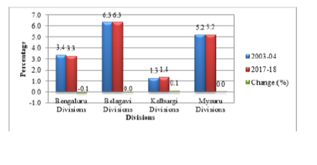
Abstract: In this paper an attempt has been made to analyse the temporal variation of land use pattern in Karnataka state: A Geographical analysis. This study is based on secondary data collected from Karnataka at a glance. Land use is clearly constrained by environmental factors such as soil characteristics, climate, topography, vegetation. But it also reflects the importance of land as a key and finite resource for most human activities including agriculture, industry, Forestry, energy production, settlement, recreation, and water catchments and storage. For measuring the temporal changes of land use pattern simple statistical equation have been employed. The study covers 30 districts of Karnataka which come under the variation in spatial variation of land use pattern examined for the periods 2003-2004 and 2017-2018.
Keywords: Land use pattern; Forest; Nonagricultural Land; Barren Land; Cultivable Waste; Permanent Pasture; Trees & Groves; Fallow Land and Net Sown Area
© 2019 Sathish & Surendra. This is an open-access article distributed under the terms of the Creative Commons Attribution License, which permits unrestricted use, distribution, and reproduction in any medium provided the original author and source are credited.
Published By Bangalore University, Bengaluru, Karnataka
Subscribe now for latest articles and news.