Geographical analysis
Department of Geography & GIS
Department of Geography & GIS
Geographical analysis
DOI: 10.53989/bu.ga.v14i2.25.1 9
Year: 2025, Volume: 14, Issue: 2, Pages: 43-52
Original Article
M S Saran1*, S Sahina2, P P Anjana3
1Scientist, Water Transportation Division (Including GIS), Kerala State Council for Science, Technology, and Environment- National Transportation Planning & Research Centre (KSCSTE-NATPAC), K. Karunakaran Transpark, Thuruvikkal, PO, Thiruvananthapuram, Kerala- 695011, India.
2Student, Indian Institute of Information Technology and Management- Kerala Technopark Campus,Thiruvananthapuram, Kerala-695 581, India.
3Project Fellow, KSCSTE-NATPAC, K. Karunakaran Transpark, Thuruvikkal, PO, Thiruvananthapuram, Kerala- 695011, India.
*Corresponding Author
Email: [email protected]
Received Date:25 January 2025, Accepted Date:25 October 2025
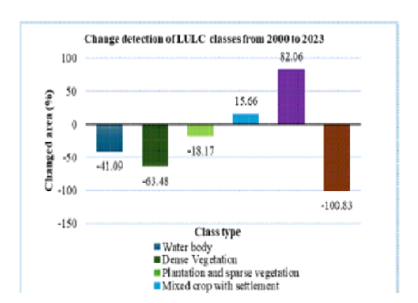
The study presents an in-depth evaluation of spatial and temporal Land Use Land Cover (LULC) modifications and their impacts on environmental and socio-economic dynamics at local scales. Utilizing Remote Sensing (RS) and Geographic Information Systems (GIS) techniques to find out the fluctuations in LULC and vegetational cover from 2000 to 2023 in Kasaragod district of Kerala. Using a supervised classification method on satellite imagery, significant changes were detected in the distribution of various LULC classes. The analysis also included effective strategies for determining vegetation cover using the Normalized Difference Vegetation Index (NDVI) technique, which highlights alterations in LULC and the extent of vegetation cover. LULC classification result indicates that dense vegetation (-63.48%), water body (-41.09%) and barren land (-100.83%) drastically declined while built-up area (82.06%) and mixed crop with settlement (15.66%) significantly increased. NDVI analysis reveals a decrease in dense vegetation (-86.01%) and sparse vegetation (-5.32%), highlighting the importance to protect natural vegetation cover. The trends identified in this research will be valuable for planners and decision-makers in the developmental analysis and future LULC management.
Keywords: Land Use Land Cover, Remote sensing, Geographic Information Systems, Normalized Difference Vegetation Index, Human Wildlife Conflict
1. Aynekulu E, Wubneh W, Birhane E, Begashaw N. Monitoring and Evaluating Land Use/ Land Cover Change Using Participatory Geographic Information System (PGIS) Tools: A Case Study of Begasheka Watershed, Tigray, Ethiopia. THE ELECTRONIC JOURNAL OF INFORMATION SYSTEMS IN DEVELOPING COUNTRIES. 2006; 25 (1). Available from: https://doi.org/10.1002/j.1681-4835.2006.tb00164.x
2. Anil NC, Sankar GJ, Rao MJ, Prasad IVRKV, Sailaja U. (2011). Studies on land use/land cover and change detection from parts of South West Godavari District, AP–using remote sensing and GIS techniques. <I>Journal of Indian Geophysical Union</I>, 15(4), 187-194.
3. Campbell JB. (1987). <I>Introduction to Remote Sensing (Guilford, New York)</I>. (Accessed 05 April 2024)
4. Chandra P. (2011). Performance evaluation of vegetation indices using remotely sensed data. <I>International Journal of Geomatics and Geosciences</I>, 2(1), 231-240.
5. Chaurasia R, Loshali DC, Dhaliwal SS, Minakshi, Sharma PK, Kudrat M, <I>et al</I>. Land use change analysis for agricultural management — A case study of Tehsil Talwandi Sabo, Punjab. Journal of the Indian Society of Remote Sensing. 1996; 24 (2). Available from: https://doi.org/10.1007/bf03016124
6. Coskun HG, Alganci U, Usta G. Analysis of Land Use Change and Urbanization in the Kucukcekmece Water Basin (Istanbul, Turkey) with Temporal Satellite Data using Remote Sensing and GIS. Sensors. 2008; 8 (11). Available from: https://doi.org/10.3390/s8117213
7. Hardin PJ, Jackson MW, Otterstrom SM. Mapping, Measuring, and Modeling Urban Growth. Geo-Spatial Technologies in Urban Environments. Available from: https://doi.org/10.1007/978-3-540-69417-5_8
8. Hossen H, Negm A. (2016). Performance of Water Bodies Extraction Techniques' Embedded In Erdas': Case Study Manzala Lake, Northeast Of Nile Delta, Egypt. In <I>Nineteenth International Water Technology Conference, IWTC19 Sharm ElSheikh</I> (pp. 21-23).
9. Lillesand TM, Kiefer RW. (1994). <I>Remote sensing and image interpretation</I> (3rd ed). John Wiley and Sons, Inc, New York.
10. Lillesand T, Kiefer RW, Chipman J. (2004). <I>Remote sensing and image interpretation</I> (5th ed). John Wiley and Sons, Inc, New York.
11. Lillesand T, Kiefer RW, Chipman J. (2007). <I>Remote sensing and image interpretation</I> (6th ed). John Wiley and Sons, Inc, New York.
12. Nath B. Quantitative assessment of forest cover change of a part of Bandarban Hill tracts using NDVI techniques. Journal of Geosciences and Geomatics. 2014; 2 (1). Available from: https://doi.org/10.12691/jgg-2-1-4
13. ISRO, NRSC. (2012). <I>Manual of national land use/land cover mapping (second cycle) using multi temporal satellite data</I>. Department of Space, Hyderabad.
14. Oppenheimer C. Book citation. SABINS, FF 1997. Remote Sensing. Principles and Interpretation, xiii+ 494 pp. New York: WH Freeman & Co. Price£ 32.95 (hard covers). ISBN 0 7167 2442 1.. Geological Magazine. 1998; 135 (1). Available from: https://doi.org/10.1017/s0016756897318251
15. Reis S. Analyzing Land Use/Land Cover Changes Using Remote Sensing and GIS in Rize, North-East Turkey. Sensors. 2008; 8 (10). Available from: https://doi.org/10.3390/s8106188
16. The Hindu. (2024). <I>Forest department’s efforts to mitigate man-animal conflict in Kasaragod bear fruit</I>. https://www.thehindu.com/news/national/kerala/forest-departments-efforts-to-mitigate-man-animal-conflict-in-kasaragod-bear fruit/article67859860.ece. (Accessed 25 May 2024)
17. The New Indian Express. (2022). <I>Forest dept sleeps as marauding jumbos raid and ravage crops worth Rs 42 crore in Kerala</I>. https://www.newindianexpress.com/states/kerala/2022/Apr/19/forest-dept-sleeps-as-marauding-jumbos-raid-and-ravage-crops-worth-rs-42-crore-in-kerala-2443913.html
18. Vivekananda GN, Swathi R, Sujith AVLN. Multi-temporal image analysis for LULC classification and change detection. European Journal of Remote Sensing. 2021; 54 (sup2). Available from: https://doi.org/10.1080/22797254.2020.1771215
© 2025 Saran et al. This is an open-access article distributed under the terms of the Creative Commons Attribution License, which permits unrestricted use, distribution, and reproduction in any medium, provided the original author and source are credited.
Published By Bangalore University, Bengaluru, Karnataka
Subscribe now for latest articles and news.