Geographical analysis

Department of Geography & GIS

Article

Geographical analysis

Year: 2024, Volume: 13, Issue: 2, Pages: 71-78

Original Article

Most Suitable SNIC Parameters and Classifier Algorithm for Object-Based Classification of Rice Crop Area using Remote Sensing Images in Google Earth Engine

Received Date:03 September 2024, Accepted Date:24 November 2024

Abstract

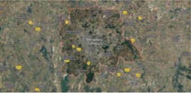
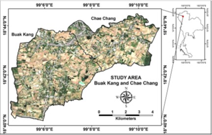
This study aims at identifying rice crop area in Chae Chang and Buak Kang subdistricts, of San Kamphaeng District, Chiang Mai Province, Thailand through Object Based Image Analysis approach. It investigates the best fit of three elements: (1) most suitable band combination of Sentinel-1 and Sentinel-2 satellite images; (2) optimum parameters for image segmentation; and (3) best performing classifier algorithm in Google Earth Engine [GEE]. The six bands of Sentinel-1 [VV & VH from ascending and descending orbits] and Sentinel-2 [B2, B3, B4 & B8] were used in different combinations. Simple Non-Iterative Clustering [SNIC] method was applied for image segmentation. Three algorithms, Support Vector Machine [SVM], Gradient Boosting Trees [GBT] and Random Forest [RF] were tested for classification and validation. The study analyzed the outcomes of five different band combinations, thirty sets of SNIC parameters - including Compactness [Co], Connectivity [Cn], Neighborhood Size [Ns], Segment Size [Ss] - and three classifier algorithms in GEE. The highest overall accuracy of 97% and a Kappa coefficient of 0.94 was achieved by using all the six bands of the images of the two satellites [Ascending orbit of Sentinel-1] with the SNIC parameter set including Co=0.1, Cn=8, Ns=10, and Ss=5 in RF classifier algorithm. The study reveals that higher Co levels lead to more circle like segments thus unsuitable for rectangular agricultural fields. The results validated against Regions of Interest [ROI] indicate that the optimized SNIC parameters effectively delineated the big and small rice fields covering 34.64 km² [73%] of the total 47.23 km² area of the two sub-districts. The study offers a pathway for improving classification accuracy in various contexts, particularly in rice area classification.

Keywords

Object-Based Image Analysis, Simple Non-Iterative Clustering, Sentinel-1 and Sentinel-2 images, Support Vector Machine Classifier, Gradient Boosting Trees Classifier, Random Forest Classifier

References

  1. Ez-Zahouani B, Kharki OE, Idé SK, Zouiten M. Determination of Segmentation Parameters for Object-Based Remote Sensing Image Analysis from Conventional to Recent Approaches: A ReviewInternational Journal of Geoinformatics2023;19(1):2342. Available from: https://doi.org/10.52939/ijg.v19i1.2497
  2. Kucharczyk M, Hay GJ, Ghaffarian S, Hugenholtz CH. Geographic Object-Based Image Analysis: A Primer and Future DirectionsRemote Sensing2020;12(12):133. Available from: https://doi.org/10.3390/rs12122012
  3. Blaschke T, Hay GJ, Kelly M, Lang S, Hofmann P, Addink E. Geographic Object-Based Image Analysis - Towards a New ParadigmISPRS Journal of Photogrammetry and Remote Sensing2014;87:180191. Available from: https://doi.org/10.1016/j.isprsjprs.2013.09.014
  4. Lang S, Hay GJ, Baraldi A, Tiede D, Blaschke T. GEOBIA Achievements and Spatial Opportunities in the Era of Big Earth Observation DataISPRS International Journal of Geo-Information2019;8(11):119. Available from: https://doi.org/10.3390/ijgi8110474
  5. Qian Y, Zhou W, Yan J, Li W, Han L. Comparing Machine Learning Classifiers for Object-Based Land Cover Classification Using Very High Resolution ImageryRemote Sensing2015;7(1):153168. Available from: https://doi.org/10.3390/rs70100153
  6. Cheng F, Ou G, Wang M, Liu C. Remote Sensing Estimation of Forest Carbon Stock Based onMachine Learning Algorithms. Forests2024;15(4):125. Available from: https://doi.org/10.3390/f15040681
  7. Zhou R, Yang C, Li E, Cai X, Yang J, Xia Y. Object-Based Wetland Vegetation Classification Using Multi-Feature Selection of Unoccupied Aerial Vehicle RGB ImageryRemote Sensing2021;13(23):121. Available from: https://doi.org/10.3390/rs13234910
  8. Gorelick N, Hancher M, Dixon M, Ilyushchenko S, Thau D, Moore R. Google Earth Engine: Planetary-scale geospatial analysis for everyoneRemote Sensing of Environment2017;202:1827. Available from: https://doi.org/10.1016/j.rse.2017.06.031
  9. Khamnoi W, Homhuan S, Suwanprasit C, Shahnawaz. Assessment of Post-Harvest Rice Crop Biomass and Carbon Stock Using Remote Sensing Data in Google Earth EngineInternational Journal of Geoinformatics2024;20(8):88101. Available from: https://doi.org/10.52939/ijg.v20i8.3459
  10. Luo C, Qi B, Liu H, Guo D, Lu L, Fu Q, et al. Using Time Series Sentinel-1 Images for Object-Oriented Crop Classification in Google Earth EngineRemote Sensing2021;13(4):119. Available from: https://doi.org/10.3390/rs13040561
  11. Akcay O, Avsar EO, Inalpulat M, Genc L, Cam A. Assessment of Segmentation Parameters for Object-Based Land Cover Classification Using Color-Infrared ImageryISPRS International Journal of Geo-Information2018;7(11):126. Available from: https://doi.org/10.3390/ijgi7110424
  12. Jamali A, Mahdianpari M, Karaş İR. A Comparison of Tree-Based Algorithms for Complex Wetland Classification Using the Google Earth Engine. The International Archives of the Photogrammetry, Remote Sensing & Spatial Information SciencesThe International Archives of the Photogrammetry, Remote Sensing and Spatial Information SciencesXLVI-4/W5-2021:313319. Available from: https://doi.org/10.5194/isprs-archives-XLVI-4-W5-2021-313-2021, 2021
  13. Sharma V, Ghosh SK. Evaluating the Potential of 8 Band Planet Scope Dataset for Crop Classification Using Random Forest and Gradient Tree Boosting by Google Earth Engine The International Archives of the Photogrammetry, Remote Sensing & Spatial Information SciencesXLVIII-M-1-2023:325330. Available from: https://doi.org/10.5194/isprs-archives-XLVIII-M-1-2023-325-2023
  14. Tassi A, Gigante D, Modica G, Martino LD, Vizzari M. Pixel- vs. Object-Based Landsat 8 Data Classification in Google Earth Engine Using Random Forest: The Case Study of Maiella National ParkRemote Sensing2021;13(12):120. Available from: https://doi.org/10.3390/rs13122299
  15. Selvaraj R, Amali DGB. Assessment of Object-Based Classification for Mapping Land Use and Land Cover Using Google EarthGlobal NEST Journal2023;25(7):131138. Available from: https://doi.org/10.30955/gnj.004829
  16. Clinton N, Holt A, Scarborough J, Yan L, Gong P. Accuracy Assessment Measures for Object-based Image Segmentation GoodnessPhotogrammetric Engineering & Remote Sensing2010;76:289299. Available from: https://dx.doi.org/10.14358/pers.76.3.289
  17. Clinton N, Holt A, Yan A, Gong P. An Accuracy Assessment Measure for Object Based Image SegmentationThe International Archives of the Photogrammetry, Remote Sensing and Spatial Information Sciences2008;XXXVII(Part B4):11891194. Available from: https://www.isprs.org/proceedings/XXXVII/congress/4_pdf/208.pdf
  18. Zhao Z, Islam F, Waseem LA, Tariq A, Nawaz M, Islam IU, et al. Comparison of Three Machine Learning Algorithms Using Google Earth Engine for Land Use Land Cover ClassificationRangeland Ecology & Management2024;92:129137. Available from: https://dx.doi.org/10.1016/j.rama.2023.10.007

Copyright

© 2024 Khamnoi et al. This is an open-access article distributed under the terms of the Creative Commons Attribution License, which permits unrestricted use, distribution, and reproduction in any medium, provided the original author and source are credited.

Published By Bangalore University, Bengaluru, Karnataka

DON'T MISS OUT!

Subscribe now for latest articles and news.