Geographical analysis
Department of Geography & GIS
Department of Geography & GIS
Geographical analysis
DOI: 10.53989/bu.ga.v14i1.24.142
Year: 2025, Volume: 14, Issue: 1, Pages: 48-53
Original Article
A Dennis1, L Senthilnathan2, T Thangaradjou3∗
1Department of Marine Biotechnology, Academy of Maritime Education & Training (AMET), Deemed to be University, Chennai, Tamil Nadu, India
2Department of Environment Biotechnology, Saveetha University, Chennai, Tamil Nadu, India
3Anusandhan National Research Foundation, Government of India, 110016, New Delhi, India
*Corresponding Author
Email: [email protected]
Received Date:18 January 2025, Accepted Date:10 August 2025
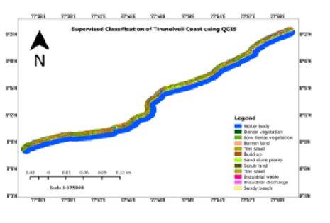
Indian coastal zones have diverse ecological and geomorphological features; however, they are recurrently influenced by anthropogenic activities and natural disturbances. Therefore, understanding coastal land use and land cover features is essential for protecting these zones. Remote sensing is a crucial tool for identifying and quantifying coastal features with synoptic coverage. The present study focuses on land use and land cover mapping along the Tirunelveli coast using QGIS and LISS III datasets. The results revealed the following land cover classifications in the Tirunelveli coastal area: barren land (17.083 km²), built-up area (26.096 km²), dense vegetation (24.167 km²), industrial discharge (3.186 km²), industrial waste (1.716 km²), low-density vegetation (36.818 km²), sand dune plants (18.568 km²), sandy beach area (32.710 km²), scrub area (14.426 km²), Teri sand area (20.553 km²), and water bodies (including freshwater and seawater), covering 305.068 km². The overall classification accuracy was 86.85%. This study provides valuable insights into the coastal regulation zone in the Tirunelveli coastal area and may contribute to future coastal conservation research.
Keywords: Tirunelveli coast, Land use land cover, QGIS, LISS III, Conservation
© 2025 Dennis et al. This is an open-access article distributed under the terms of the Creative Commons Attribution License, which permits unrestricted use, distribution, and reproduction in any medium, provided the original author and source are credited.
Published By Bangalore University, Bengaluru, Karnataka
Subscribe now for latest articles and news.