Geographical analysis
Department of Geography & GIS
Department of Geography & GIS
Geographical analysis
DOI: 10.53989/bu.ga.v12i1.23.5
Year: 2023, Volume: 12, Issue: 1, Pages: 39-44
Original Article
R Shiva Kumar1, K R Prasanna Kumar2
1 Faculty, Department of Geography, Jnanabharathi Campus, Bangalore University, Bengaluru
2 Associate Professor, Dept. of Geography, Govt. First Grade College, Vijayanagara, Bengaluru
Received Date:25 February 2023, Accepted Date:09 June 2023
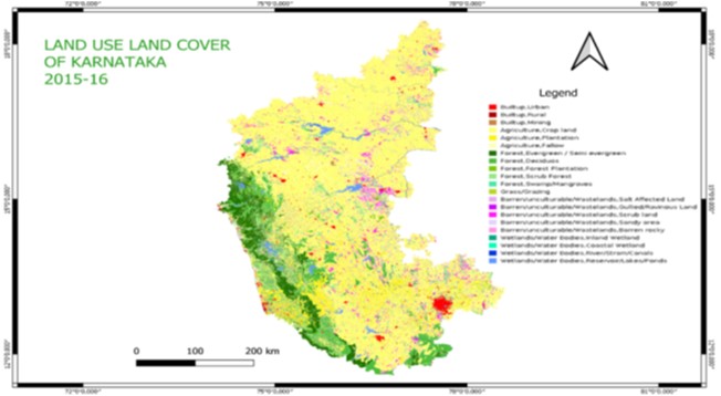
This study sheds light on the dynamic patterns of land use and land cover changes in Karnataka State, India, utilizing Bhuvan satellite data. Over a span of three years (2005-06, 2011-12, and 2015-16), digital change detection techniques were employed to analyze and map the evolving landscape. The investigation utilized a combination of Bhuvan Geoportal and QGIS open-source software for data extraction, thematic mapping, and analysis. Statistical data, graphical representations, and pie diagrams were utilized to quantify and visualize the observed changes in land utilization. The analysis revealed significant fluctuations in built-up areas, agricultural lands, forests, and water bodies. These findings provide valuable insights into the evolving landscape of Karnataka, highlighting the need for sustainable land management practices. Decision-makers can utilize this information to formulate effective policies and strategies aimed at conserving natural resources, preserving biodiversity, and promoting sustainable development in the region.
Keywords
Land Use, Land Cover, Change Detection, Bhuvan Satellite Data, Karnataka
© 2023 Shiva Kumar & Prasanna Kumar. This is an open-access article distributed under the terms of the Creative Commons Attribution License, which permits unrestricted use, distribution, and reproduction in any medium, provided the original author and source are credited.
Published By Bangalore University, Bengaluru, Karnataka
Subscribe now for latest articles and news.