Geographical analysis
Department of Geography & GIS
Department of Geography & GIS
Geographical analysis
Year: 2020, Volume: 9, Issue: 2, Pages: 33-41
Original Article
Rashmi Priya1, R Shiva Kumar2, Shiv Kumar Naiklal3, Anjan Kumar4
1Student, Department of Geography and Geoinformatics, Bangalore University, Bengaluru
2Guest Faculty, Department of Geography, Bangalore University, Bengaluru
3Scientist, Karnataka State Natural Disaster Monitoring Centre, Bengaluru
4Karnataka State Natural Disaster Monitoring Centre, Bengaluru
Received Date:05 July 2020, Accepted Date:18 October 2020
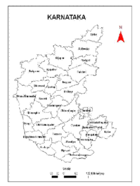
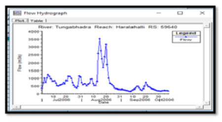
The Hydrologic Engineering Center’s River Analysis System (HEC-RAS) can model flood events and produce water surface profiles over the length of the modeled stream. Flood Inundation Modelling is important for engineers, planners, and government agencies used for municipal and urban growth planning, emergency action plans, flood insurance rates, and ecological studies. This paper describes the application of the HEC-RAS model for the development of floodplain maps for the part of Tungabhadra River, Haralahalli discharge site that lies in Haveri district of Karnataka. Since most of the flood plain area/area vulnerable to flooding is currently used for agriculture. By understanding the extent of flooding and floodwater inundation, we can decide how to best allocate resources to prepare for emergencies.
Keywords: Flood; Inundation; HEC-RAS Modelling
Safaripour, M., Monavari, M., Zare, M., Abedi, Z., & Gharagozlou, A. (2012). Flood Risk Assessment Using GIS (Case Study: Golestan Province, Iran). Polish Journal of Environmental Studies.
Youssef, Ahmed M., Biswajeet Pradhan, and Abdallah Mohamed Hassan. "Flash flood risk estimation along the St. Katherine road, southern Sinai, Egypt using GIS based morphometry
Sowmya, K., C. M. John, and N. K. Shrivasthava. "Urban flood vulnerability zoning of Cochin City, southwest coast of India, using remote sensing and GIS”
Singh, Anupam K., and Arun K. Sharma. "GIS and a remote sensing-based approach for urban flood-plain mapping for the Tapi catchment, India." IAHS publication 331 (2009): 389.
Wicht, Marzena, and Katarzyna Osinska-Skotak. "Identifying urban areas prone to flash floods using GIS–preliminary results."
Khattak, Muhammad Shahzad, et al. "Floodplain mapping using HEC-RAS and ArcGIS: a case study of Kabul River." Arabian Journal for Science and Engineering 41.4 (2016): 1375-1390.
Rangari, Vinay Ashok, et al. "Floodplain Mapping and Management of Urban Catchment Using HEC-RAS: A Case Study of Hyderabad City."
Goodell, C., and C. Warren. "Flood inundation mapping using HEC-RAS." Obras y Proyectos (2006):
Kowalczuk, Zdzisław, Mateusz Świergal, and Mirosław Wróblewski. "River flow simulation based on the HEC-RAS system." International Conference on Diagnostics of Processes and Systems. Springer, Cham, 2017.
Surwase, Tushar, et al. "Flood Inundation Simulation of Mahanadi River, Odisha During September 2008 by Using HEC-RAS 2D Model." Proceedings of International Conference on Remote Sensing for Disaster Management. Springer, Cham, 2019.
Kumar, Neeraj, et al. "Applicability of HEC-RAS & GFMS tool for 1D water surface elevation/flood modeling of the river: a Case Study of River Yamuna at Allahabad (Sangam), India." Modeling Earth Systems and Environment 3.4 (2017): 1463-1475.
Panda, Prafulla Kumar, and Santiswarup Sahoo. "Modelling of Floodplain Using Recent Technology." European Journal of Advances in Engineering and Technology 2.7 (2015): 23-28.
Das, Bahnisikha, and B. S. Sil. "Assessment of Sedimentation in Barak River Reach Using HEC-RAS." Development of Water Resources in India. Springer, Cham, 2017. 95-102.
Hammond, Michael J., et al. "Urban flood impact assessment: A state-of-the-art review." Urban Water Journal 12.1 (2015): 14-29.
© 2020 Priya et al. This is an open-access article distributed under the terms of the Creative Commons Attribution License, which permits unrestricted use, distribution, and reproduction in any medium, provided the original author and source are credited.
Published By Bangalore University, Bengaluru, Karnataka
Subscribe now for latest articles and news.