Geographical analysis
Department of Geography & GIS
Department of Geography & GIS
Geographical analysis
DOI: 10.53989/bu.ga.v14i2.25.2 7
Year: 2025, Volume: 14, Issue: 2, Pages: 53-61
Original Article
Suzan Karmoka1*, Ashok D Hanjagi1
1Department of Geography and GeoInformatics, Bangalore University, Jnana Bharathi, Bengaluru, 560056, Karnataka, India
*Corresponding Author
Email: [email protected]
Received Date:05 February 2025, Accepted Date:25 October 2025
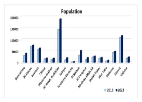
Many developing countries face challenges in urban planning, often failing to allocate sufficient space, particularly green areas, to support healthy living conditions and essential services. Latakia, Syria, exemplifies this issue, especially following the massive influx of displaced populations due to the Syrian crisis over the past decade. As one of the country's safest cities, Latakia has experienced significant population pressure, leading to unregulated urban expansion at the expense of green spaces. This unplanned growth has intensified the urban heat island (UHI) effect. To assess the rising UHI effect in Latakia, this study applied the Heat Risk Index (HRI), calculated using a five-degree weighting system. The findings indicate that in 2013, no sector exhibited extreme heat risk, with levels ranging from mild to severe. However, by 2023, heat risk had escalated across most sectors. Notably, Al Sleibeh and Al-Raml Aljanobi sectors reached extreme heat risk levels, correlating with population increases of 64% and 24%, respectively. Meanwhile, the Southern Corniche and Mashrou Alqalaa sectors maintained moderate risk levels. The Al-Datour sector demonstrated the most significant change, with its HRI rising by two levels to a severe risk category, primarily due to an 8% urban expansion over agricultural lands. To mitigate UHI effects, Latakia urgently requires innovative adaptation strategies. Addressing climate change impacts and population pressures necessitates strategic, localized planning. HRI can serve as a foundation for these efforts by pinpointing priority areas for targeted adaptation interventions.
Keywords: Heat Risk Index, Latakia, Population Density, Urban Heat Islands
1. Jiang J, Tian G. Analysis of the impact of Land use/Land cover change on Land Surface Temperature with Remote Sensing. Procedia Environmental Sciences. 2010; 2 Available from: https://doi.org/10.1016/j.proenv.2010.10.062
2. Pandey B, Joshi PK, Seto KC. Monitoring urbanization dynamics in India using DMSP/OLS night time lights and SPOT-VGT data. International Journal of Applied Earth Observation and Geoinformation. 2013; 23 Available from: https://doi.org/10.1016/j.jag.2012.11.005
3. Liu Y, Wang Y, Peng J, Du Y, Liu X, Li S, <I>et al</I>. Correlations between Urbanization and Vegetation Degradation across the World’s Metropolises Using DMSP/OLS Nighttime Light Data. Remote Sensing. 2015; 7 (2). Available from: https://doi.org/10.3390/rs70202067
4. Baker JL. Bangladesh-Dhaka: Improving Living Conditions for the Urban Poor. 2007; Available from: https://doi.org/10.11588/xarep.00003567
5. Santos MJ, Smith AB, Dekker SC, Eppinga MB, Leitão PJ, Moreno-Mateos D, <I>et al</I>. The role of land use and land cover change in climate change vulnerability assessments of biodiversity: a systematic review. Landscape Ecology. 2021; 36 (12). Available from: https://doi.org/10.1007/s10980-021-01276-w
6. Rahaman S, Kumar P, Chen R, Meadows ME, Singh RB. Remote Sensing Assessment of the Impact of Land Use and Land Cover Change on the Environment of Barddhaman District, West Bengal, India. Frontiers in Environmental Science. 2020; 8 Available from: https://doi.org/10.3389/fenvs.2020.00127
7. Chorianopoulos I, Pagonis T, Koukoulas S, Drymoniti S. Planning, competitiveness and sprawl in the Mediterranean city: The case of Athens. Cities. 2010; 27 (4). Available from: https://doi.org/10.1016/j.cities.2009.12.011
8. Chen L, Yu B, Yang F, Mayer H. Intra-urban differences of mean radiant temperature in different urban settings in Shanghai and implications for heat stress under heat waves: A GIS-based approach. Energy and Buildings. 2016; 130 Available from: https://doi.org/10.1016/j.enbuild.2016.09.014
9. Akbari H, Cartalis C, Kolokotsa D, Muscio A, Pisello AL, Rossi F, <I>et al</I>. Local Climate Change and Urban Heat Island Mitigation Techniques - The State of the Art. Journal of Civil Engineering and Management. 2015; 22 (1). Available from: https://doi.org/10.3846/13923730.2015.1111934
10. Fischer E, Detommaso M, Martinico F, Nocera F, Costanzo V. A risk index for assessing heat stress mitigation strategies. An application in the Mediterranean context. Journal of Cleaner Production. 2022; 346 Available from: https://doi.org/10.1016/j.jclepro.2022.131210
11. Khadour N, Fekete A, Sárospataki M. The Role of the Master Plan in City Development, Latakia Master Plan in an International Context. Land. 2023; 12 (8). Available from: https://doi.org/10.3390/land12081634
12. Khan Z, Javed A. Correlation between land surface temperature (LST) and normalized difference vegetation index (NDVI) in Wardha Valley Coalfield, Maharashtra, Central India. Nova Geodesia. 2022; 2 (3). Available from: https://doi.org/10.55779/ng2353
13. Ghosh S, Kumar D, Kumari R. Assessing spatiotemporal dynamics of land surface temperature and satellite-derived indices for new town development and suburbanization planning. Urban Governance. 2022; 2 (1). Available from: https://doi.org/10.1016/j.ugj.2022.05.001
14. Portela CI, Massi KG, Rodrigues T, Alcântara E. Impact of urban and industrial features on land surface temperature: Evidences from satellite thermal indices. Sustainable Cities and Society. 2020; 56 Available from: https://doi.org/10.1016/j.scs.2020.102100
15. Kriegler FJ, Malila WA, Nalepka RF, Richardson W. "Preprocessing Transformations and Their Effect on Multispectral Recognition." In Proceedings of the Sixth International Symposium on Remote Sensing of Environment, 97-131. University of Michigan, Ann Arbor, MI, (1969).
16. Avdan U, Jovanovska G. Algorithm for Automated Mapping of Land Surface Temperature Using LANDSAT 8 Satellite Data. Journal of Sensors. 2016; 2016 Available from: https://doi.org/10.1155/2016/1480307
17. Gandhi GM, Parthiban S, Thummalu N, Christy A. NDVI: Vegetation Change Detection Using Remote Sensing and Gis – A Case Study of Vellore District. Procedia Computer Science. 2015; 57 Available from: https://doi.org/10.1016/j.procs.2015.07.415
18. Karmoka S, Hanjagi AD. The Impact of Precipitation Distribution on the Natural and Cultivated Vegetation Cover Changes in the Syrian Coastal Area for the Period 2000-2019. Geo-Eye. 2022; 11 (1). Available from: https://doi.org/10.53989/bu.ge.v11i1.3
19. Aik DHJ, Ismail MH, Muharam FM. Land Use/Land Cover Changes and the Relationship with Land Surface Temperature Using Landsat and MODIS Imageries in Cameron Highlands, Malaysia. Land. 2020; 9 (10). Available from: https://doi.org/10.3390/land9100372
20. Karmoka ROSA, Jiroudieh A, AL-Jbawi Z. Estimating Age and Tree Density for Jobet Berghal Pinus brutia Ten. Forest Stands Using Landsat ETM Images. 2020; Available from: http://doi.org/10.13140/RG.2.2.26507.50722
21. El-Hattab M, Amany SM, Lamia GE. Monitoring and assessment of urban heat islands over the Southern region of Cairo Governorate, Egypt. The Egyptian Journal of Remote Sensing and Space Science. 2018; 21 (3). Available from: https://doi.org/10.1016/j.ejrs.2017.08.008
22. Abdo H, Salloum J. Spatial assessment of soil erosion in Alqerdaha basin (Syria). Modeling Earth Systems and Environment. 2017; 3 (1). Available from: https://doi.org/10.1007/s40808-017-0294-z
23. Mathbout S, Martin-Vide J, Bustins JAL. Drought characteristics projections based on CMIP6 climate change scenarios in Syria. Journal of Hydrology: Regional Studies. 2023; 50 Available from: https://doi.org/10.1016/j.ejrh.2023.101581
24. Alsafadi N, Ansari A, Mokhtar A, Mohammed S, Elbeltagi A, Sammen SS, <I>et al</I>. An evapotranspiration deficit-based drought index to detect variability of terrestrial carbon productivity in the Middle East. Environmental Research Letters. 2022; 17 (1). Available from: https://doi.org/10.1088/1748-9326/ac4765
25. Karmoka SF, Al Haj Ahmad A, Alkhaled EA. Identifying Drought Classes in Northwest Syria Using MODIS Satellite Image Spectral Indices EVI, LAI, TVI. Scientific Journal of King Faisal University. 2019; 20 (1). Available from: http://doi.org/10.13140/RG.2.2.20054.37447/1
26. Younes A, Ahmad A, Hanjagi AD, Nair AM. Understanding Dynamics of Land Use & Land Cover Change Using GIS & Change Detection Techniques in Tartous, Syria. European Journal of Geography. 2023; 14 (3). Available from: https://doi.org/10.48088/ejg.a.you.14.3.020.041
27. Parveen S, Basheer J, Praveen B. A Literature Review on Land Use Land Cover Changes. International Journal of Advanced Research. 2018; 6 (7). Available from: https://doi.org/10.21474/ijar01/7327
28. Mohamed MA. An Assessment of Forest Cover Change and Its Driving Forces in the Syrian Coastal Region during a Period of Conflict, 2010 to 2020. Land. 2021; 10 (2). Available from: https://doi.org/10.3390/land10020191
29. Rahmoun T, Zhao W, Hammad M, Hassan M. Ruralization vs. Urbanization Sprawl as Guiding Regional Planning: Development Scenario for Rivers Watershed in the Southern Syrian Coastal Region. IOP Conference Series: Earth and Environmental Science. 2018; 151 Available from: https://doi.org/10.1088/1755-1315/151/1/012033
30. Rudel TK, Coomes OT, Moran E, Achard F, Angelsen A, Xu J, <I>et al</I>. Forest transitions: towards a global understanding of land use change. Global Environmental Change. 2005; 15 (1). Available from: https://doi.org/10.1016/j.gloenvcha.2004.11.001
31. Dudley JP, Ginsberg JR, Plumptre AJ, Hart JA, Campos LC. Effects of War and Civil Strife on Wildlife and Wildlife Habitats. Conservation Biology. 2002; 16 (2). Available from: https://doi.org/10.1046/j.1523-1739.2002.00306.x
32. Murphy P, Lobdell D. U.S. Environmental Protection Agencyʼs (EPA) 2008 Report on the Environment (ROE): Identified Gaps and Future Challenges for Human Exposure and Health Indicators. Epidemiology. 2009; 20 Available from: https://doi.org/10.1097/01.ede.0000362984.98566.ed
33. Bowler DE, Buyung-Ali L, Knight TM, Pullin AS. Urban greening to cool towns and cities: A systematic review of the empirical evidence. Landscape and Urban Planning. 2010; 97 (3). Available from: https://doi.org/10.1016/j.landurbplan.2010.05.006
34. Eum JH, Scherer D, Fehrenbach U, Köppel J, Woo JH. Integrating urban climate into urban master plans using spatially distributed information—The Seoul example. Land Use Policy. 2013; 34 Available from: https://doi.org/10.1016/j.landusepol.2013.03.016
© 2025 Karmoka & Hanjagi. This is an open-access article distributed under the terms of the Creative Commons Attribution License, which permits unrestricted use, distribution, and reproduction in any medium, provided the original author and source are credited.
Published By Bangalore University, Bengaluru, Karnataka
Subscribe now for latest articles and news.