Geographical analysis

Department of Geography & GIS

Article

Geographical analysis

Year: 2024, Volume: 13, Issue: 2, Pages: 63-70

Original Article

Evaluation of Topographical Factors Influence on Agricultural Land in Poonch District of Jammu and Kashmir, India

Received Date:06 December 2024, Accepted Date:10 December 2024

Abstract

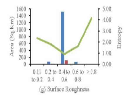
Topographical factors such as “elevation, slope, aspect, curvature, relief amplitude, incision depth, surface roughness, and standard deviation of elevation (STD)” significantly impact agricultural land. This study quantitatively assesses the linkage between topographical factors and agricultural lands. With the help of Geographical Information System (GIS) techniques, statistically remarkable digitized data of agricultural lands and ALOS PALSAR DEM were applied to examine the connotation between topographical constraints and agrarian lands. This study used eight topographical factors and the concept of location entropy to determine how agricultural lands were distributed spatially in the study area. It has been found that the topography varied in the study area, location entropy shows that agricultural lands have unique distribution patterns. The findings indicate that agricultural lands are present on plain or less inclined slopy areas. Moreover, with the concept of location entropy (P), agricultural land suitability was classified into three degrees: most suitable (P≥2), standard suitable(P≥1), and unsuited (P<1). The study’s outcomes denoted that the standard suitable (37.1% - 77.9%) and most suitable (17.9% - 35.6%) areas are significant in Poonch district compared to unsuitable regions (4.8% - 29.2%).

Keywords: Agricultural land, Geographical Information System (GIS), Location Entropy, Topographical factors

References

  1. Tarolli P, Straffelini E. Agriculture in Hilly and Mountainous Landscapes: Threats, Monitoring and Sustainable Management. Geography and Sustainability. 2020;1(1):70–76. Available from: https://doi.org/10.1016/j.geosus.2020.03.003
  2. Choenkwan S, Fox JM, Rambo AT. Agriculture in the Mountains of Northeastern Thailand: Current Situation and Prospects for Development. Mountain Research and Development. 2014;34(2):95–106. Available from: https://doi.org/10.1659/MRD-JOURNAL-D-13-00121.1
  3. Godwin RJ, Miller PCH. A review of the technologies for mapping within-field variability. Biosystems Engineering. 2003;84(4):393–407. Available from: https://doi.org/10.1016/S1537-5110(02)00283-0
  4. Kumhálová J, Kumhála F, Kroulík M, Matějková Š. The impact of topography on soil properties and yield and the effects of weather conditions. Precision Agriculture. 2011;12(6):813–830. Available from: https://doi.org/10.1007/s11119-011-9221-x
  5. Senbeta F, Schmitt C, Woldemariam T, Boehmer HJ, Denich M. Plant Diversity, Vegetation Structure and Relationship between Plant Communities and Environmental Variables in the Afromontane forests of Ethiopia. SINET- Ethiopian Journal of Science. 2014;37(2):113–130. Available from: http://ejol.aau.edu.et/index.php/SINET/article/view/7148
  6. Kravchenko AN, Bullock DG. Correlation of corn and soybean grain yield with topography and soil properties. Agronomy journal. 2000;92(1):75–83. Available from: https://doi.org/10.2134/agronj2000.92175x
  7. FAO in India. Food and Agricultural Organization (FAO) of the United Nations. . Available from: https://www.fao.org/india/en/
  8. Comprehensive-District Agriculture Plan (C-DAP) Department of Agriculture, Poonch, Govt. of Jammu & Kashmir. 2016;p. 1–68. Available from: https://diragrijmu.nic.in/C-DAP-Poonch/C-DAP-Poonch.pdf
  9. ASF Data Search Vertex. Nasa Earthdata. 2022. Available from: https://search.asf.alaska.edu
  10. Maqsoom A, Aslam B, Khalil U, Azam S, Kazmi ZA, Rana MUA. Discovering patterns in the topography of existing settlements: the case of the China-Pakistan Economic Corridor (CPEC) route. Arabian Journal of Geosciences. 2023;16(1). Available from: https://doi.org/10.1007/s12517-022-11096-0
  11. Ma S, Liu J, Zhao Z, Wang Y, Yang W, Gu Y. Research on the terrain differential characteristics of rural residents in Fuping County, Hebei Province. Research of Soil and Water Conservation. 2016;6:327–332. Available from: https://caod.oriprobe.com/articles/49714458/Research_on_the_Terrain_Differential_Characteristi.htm
  12. Tu H, Liu ZD. Demonstrating on optimum statistic unit of relief amplitude in China. Journal of Hubei University. 1990;3:266–271.
  13. Xi C, Qian T, Chi Y, Chen J, Wang J. Relationship between settlements and topographical factors: An example from Sichuan Province, China. Journal of Mountain Science. 2018;15(9):2043–2054. Available from: https://doi.org/10.1007/s11629-018-4863-z

Copyright

© 2024 Iqbal et al. This is an open-access article distributed under the terms of the Creative Commons Attribution License, which permits unrestricted use, distribution, and reproduction in any medium, provided the original author and source are credited.

Published By Bangalore University, Bengaluru, Karnataka

DON'T MISS OUT!

Subscribe now for latest articles and news.