Geographical analysis
Department of Geography & GIS
Department of Geography & GIS
Geographical analysis
DOI: 10.53989/bu.ga.v14i2.24.262
Year: 2025, Volume: 14, Issue: 2, Pages: 5-13
Original Article
S M Kumar1∗, P Thirumalai2, R Thanuja Krishnan3, K Prakash4, P Masilamani5, J Killivalavan6
1Research Scholar, PG and Research Department of Geography, Government Arts College (A), Kumbakonam, 612 002, Tamil Nadu, India
2Associate Professor, PG and Research Department of Geography, Government Arts College (A), Kumbakonam, 612 002, Tamil Nadu, India
3Project Associate-I, Department of Geography, Bharathidasan University, Tiruchirappalli, 620024, Tamil Nadu, India
4Guest Faculty, Department of Geography, Bharathidasan University, Tiruchirappalli, 620024, Tamil Nadu, India
5Assistant Professor, Department of Geography, Bharathidasan University, Tiruchirappalli, 620024, Tamil Nadu, India
6Chief Executive Officer, Parallel Universe Business Intelligence & Media Pvt. Ltd., Chennai, 600033, Tamil Nadu, India
*Corresponding Author
Email: [email protected]
Received Date:08 December 2024, Accepted Date:10 August 2025
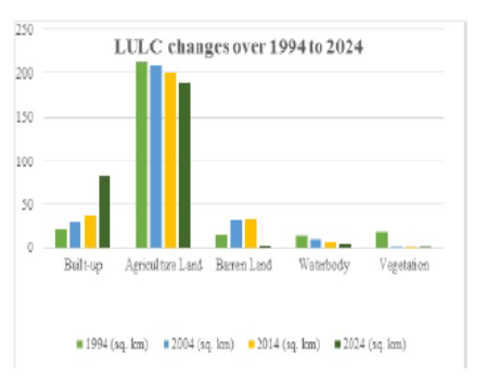
Over time to time, the urban areas have been expanding at a rate with exponential growth of the population. This rapid invasion of population leads to a change in the landuse land cover pattern of the areas. Therefore, making cities sustainably suitable for living can be achieved by monitoring the spatiotemporal dynamics of land use and land cover changes, as well as the urban expansion pattern. This study primarily focuses on urban expansion and land-use/land-cover changes in Kumbakonam Taluk, Thanjavur District, from 1994 to 2024. The present study investigated spatiotemporal land-use patterns, SAVI, NDWI, NDBI, and IBI for Kumbakonam Taluk for 1994, 2004, 2014, and 2024 using Landsat 5 and Landsat 8 datasets. The landuse and land cover changes of Kumbakonam Taluk were generated using the supervised classification method with the Support Vector Machine algorithm. The result of the LULC shows that the built-up classes have rapidly expanded from 1994 to 2024, from 21 sq. km to 82.3 sq. km, respectively. The city's periphery has a high expansion of built-up areas resulting from the conversion of agricultural land from 2014 to 2024. Over the study period, agricultural land, vegetation, and water body were reduced to 22 sq. km, 17.3 sq. km and 9 sq. km, respectively. The result from IBI shows the higher expansion of urban areas on the peripheries of the city towards its western side from 1994 to 2024. The present study provides a framework for analyzing land use and land cover changes over three decades, as well as the direction and pattern of urban expansion. The results of the study will help not only urban planners but also policymakers to develop new sustainable strategies for urban development, assess environmental impacts such as the loss of green cover, and aid in formulating effective spatial policies and governance strategies.
Keywords: IBI, LULC, SAVI, NDBI, MNDWI
© 2025 Kumar et al. This is an open-access article distributed under the terms of the Creative Commons Attribution License, which permits unrestricted use, distribution, and reproduction in any medium, provided the original author and source are credited.
Published By Bangalore University, Bengaluru, Karnataka
Subscribe now for latest articles and news.