Geographical analysis
Department of Geography & GIS
Department of Geography & GIS
Geographical analysis
Year: 2024, Volume: 13, Issue: 2, Pages: 10-13
Original Article
R Soundarya1, Sawant Sushant Anil1∗
1School of Life Sciences, JSS Academy of Higher Education and Research, Mysuru, Karnataka, India
*Corresponding Author
Email: [email protected]
Received Date:02 March 2024, Accepted Date:04 March 2024
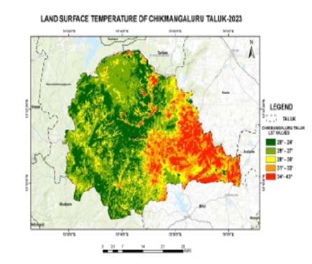
This comprehensive report presents a meticulous geospatial analysis of land surface temperature (LST) changes in Chikmagalur Taluk, Karnataka, India, leveraging Landsat 8 Level 1 satellite imagery. The study aims to understand the temporal dynamics of LST and its environmental implications. We detail a comprehensive methodology encompassing radiometric calibration, spectral indices, and advanced spatial modeling. Notably, the results reveal a diverse pattern of LST changes, with the eastern part of the Taluk showing localized decreases, while the hill regions in the west and central areas exhibit notable temperature increases. These findings suggest a potential link between recent environmental incidents and LST fluctuations in the region.
Keywords: LST, Landsat 8, Level 1, Band 10, band 4, band 5
© 2024 Soundarya & Anil. This is an open-access article distributed under the terms of the Creative Commons Attribution License, which permits unrestricted use, distribution, and reproduction in any medium, provided the original author and source are credited.
Published By Bangalore University, Bengaluru, Karnataka
Subscribe now for latest articles and news.